Posts

Es werden Posts vom April 16, 2015 angezeigt.

IZU ISLANDS, JAPAN REGION-4.6

Bild
Magnitude M 4.6 Region IZU ISLANDS, JAPAN REGION Date time 2015-04-16 20:36:22.7 UTC Location 30.43 N ; 143.02 E Depth 10 km Distances 661 km SE of Tokyo, Japan / pop: 8,336,599 / local time: 05:36:22.7 2015-04-17 1677 km SE of Seoul, South Korea / pop: 10,349,312 / local time: 05:36:22.7 2015-04-17 1708 km N of Saipan, Northern Mariana Islands / pop: 48,220 / local time: 06:36:22.7 2015-04-17 Source parameters provided by:   GeoForschungsZentrum (GEOFON) -- Potsdam, Germany (GFZ)
CAUTERETS.FRANCIA-1.7

Bild
Evento Fecha Hora (GMT)* Latitud Longitud Prof. (km) Int. (***) Máx. Mag. Tipo (**) Mag. Localización 1325518 16/04/2015 19:08:47 42.8548 -0.3028     1.7 4 W CAUTERETS.FRA

CRETE, GREECE-4.3-3.5-3.8-4.2-3.0-3.7-3.0

Bild
Magnitude M 4.3 Region CRETE, GREECE Date time 2015-04-16 20:15:51.4 UTC Location 34.86 N ; 26.91 E Depth 80 km Distances 395 km S of İzmir, Turkey / pop: 2,500,603 / local time: 23:15:51.4 2015-04-16 169 km E of Irákleion, Greece / pop: 137,154 / local time: 23:15:51.4 2015-04-16 115 km E of Ágios Nikólaos, Greece / pop: 10,799 / local time: 23:15:51.4 2015-04-16 71 km SE of Palaíkastron, Greece / pop: 1,094 / local time: 23:15:51.4 2015-04-16 Source parameters not yet reviewed by a seismologist Magnitude ML 3.5 Region CRETE, GREECE Date time 2015-04-16 20:05:49.9 UTC Location 34.41 N ; 26.66 E Depth 100 km Distances 446 km S of İzmir, Turkey / pop: 2,500,603 / local time: 23:05:49.9 2015-04-16 172 km SE of Irákleion, Greece / pop: 137,154 / local time: 23:05:49.9 2015-04-16 123 km SE of Ágios Nikólaos, Greece / pop: 10,799 / local time: 23:05:49.9 2015-04-16 95 km SE of Makry Gialos, Greece / pop: 4,204 / local time: 23:05:49.9 2015-04-16 Source paramete

DAS WETTER AM FREITAG-17-04-2015

Bild

GREECE-Earthquake risk April 16-17

Bild

CRETE, GREECE-5.0-changed-4.9

Bild
Magnitude M 5.0 Region CRETE, GREECE Date time 2015-04-16 19:02:13.8 UTC Location 35.05 N ; 26.97 E Depth 2 km Distances 373 km S of İzmir, Turkey / pop: 2,500,603 / local time: 22:02:13.8 2015-04-16 169 km E of Irákleion, Greece / pop: 137,154 / local time: 22:02:13.8 2015-04-16 116 km E of Ágios Nikólaos, Greece / pop: 10,799 / local time: 22:02:13.8 2015-04-16 55 km SW of Kárpathos, Greece / pop: 2,243 / local time: 22:02:13.8 2015-04-16 Source parameters not yet reviewed by a seismologist

CRETE, GREECE-4.5-4.4-DODECANESE ISLANDS, GREECE-5.0-changed-4.9

Bild
Magnitude M 4.5 Region CRETE, GREECE Date time 2015-04-16 18:50:22.0 UTC Location 35.12 N ; 26.77 E Depth 2 km Distances 367 km S of İzmir, Turkey / pop: 2,500,603 / local time: 21:50:22.0 2015-04-16 150 km E of Irákleion, Greece / pop: 137,154 / local time: 21:50:22.0 2015-04-16 97 km E of Ágios Nikólaos, Greece / pop: 10,799 / local time: 21:50:22.0 2015-04-16 48 km E of Palaíkastron, Greece / pop: 1,094 / local time: 21:50:22.0 2015-04-16 Source parameters not yet reviewed by a seismologist Magnitude M 4.4 Region CRETE, GREECE Date time 2015-04-16 18:50:22.1 UTC Location 35.13 N ; 26.77 E Depth 2 km Distances 366 km S of İzmir, Turkey / pop: 2,500,603 / local time: 21:50:22.1 2015-04-16 150 km E of Irákleion, Greece / pop: 137,154 / local time: 21:50:22.1 2015-04-16 97 km E of Ágios Nikólaos, Greece / pop: 10,799 / local time: 21:50:22.1 2015-04-16 48 km E of Palaíkastron, Greece / pop: 1,094 / local time: 21:50:22.1 2015-04-16 Source parameters not yet

Very strong earthquake offshore Eastern Crete, Greece

Bild
Last update: April 16, 2015 at 6:55 pm by By Armand Vervaeck Earthquake-report Update 19:24 UTC : Professor Max Wyss, who specializes in theoretical prognoses of injuries and fatalities expects : NO injuries and NO fatalities, always a great sign to see Update 19:23 UTC   : The earthquake is very shallow but at a safe distance from the coast to aboid serious damage (we think) 367 km S of İzmir, Turkey / pop: 2,500,603 / local time: 21:07:43.4 2015-04-16 160 km E of Irákleion, Greece / pop: 137,154 / local time: 21:07:43.4 2015-04-16 107 km E of Ágios Nikólaos, Greece / pop: 10,799 / local time: 21:07:43.4 2015-04-16 53 km SW of Kárpathos, Greece / pop: 2,243 / local time: 21:07:43.4 2015-04-16

CRETE, GREECE-6.1-4.6-3.9

Bild
You felt this earthquake. Tell us! Magnitude Mw 6.1 Region CRETE, GREECE Date time 2015-04-16 18:07:43.8 UTC Location 35.02 N ; 26.81 E Depth 25 km Distances 378 km S of İzmir, Turkey / pop: 2,500,603 / local time: 21:07:43.8 2015-04-16 156 km E of Irákleion, Greece / pop: 137,154 / local time: 21:07:43.8 2015-04-16 102 km E of Ágios Nikólaos, Greece / pop: 10,799 / local time: 21:07:43.8 2015-04-16 55 km E of Palaíkastron, Greece / pop: 1,094 / local time: 21:07:43.8 2015-04-16 Source parameters reviewed by a seismologist Magnitude M 4.6 Region CRETE, GREECE Date time 2015-04-16 18:14:17.8 UTC Location 35.15 N ; 26.79 E Depth 2 km Distances 363 km S of İzmir, Turkey / pop: 2,500,603 / local time: 21:14:17.8 2015-04-16 151 km E of Irákleion, Greece / pop: 137,154 / local time: 21:14:17.8 2015-04-16 98 km E of Ágios Nikólaos, Greece / pop: 10,799 / local time: 21:14:17.8 2015-04-16 50 km E of Palaíkastron, Greece / pop: 1,094 / local time: 21:14:17.8 2015-04-16

CRETE, GREECE-3.0

Bild
Magnitude M 3.0 Region CRETE, GREECE Date time 2015-04-16 16:02:31.3 UTC Location 35.22 N ; 23.27 E Depth 15 km Distances 309 km S of Athens, Greece / pop: 729,137 / local time: 19:02:31.3 2015-04-16 171 km W of Irákleion, Greece / pop: 137,154 / local time: 19:02:31.3 2015-04-16 75 km SW of Chaniá, Greece / pop: 54,565 / local time: 19:02:31.3 2015-04-16 38 km W of Palaiochóra, Greece / pop: 2,372 / local time: 19:02:31.3 2015-04-16 Source parameters not yet reviewed by a seismologist

MONTENEGRO-2.7-3.2-2.7

Bild
Magnitude ML 2.7 Region MONTENEGRO Date time 2015-04-16 16:10:20.8 UTC Location 42.96 N ; 18.73 E Depth 5 km Distances 72 km NW of Podgorica, Montenegro / pop: 136,473 / local time: 18:10:20.8 2015-04-16 63 km NE of Dubrovnik, Croatia / pop: 28,428 / local time: 18:10:20.8 2015-04-16 26 km E of Bileća, Bosnia and Herzegovina / pop: 13,257 / local time: 18:10:20.8 2015-04-16 Source parameters provided by: Magnitude ML 3.2 Region MONTENEGRO Date time 2015-04-16 16:30:32.8 UTC Location 43.21 N ; 18.93 E Depth 2 km Distances 85 km SE of Sarajevo, Bosnia and Herzegovina / pop: 696,731 / local time: 18:30:32.8 2015-04-16 17 km W of Žabljak, Montenegro / pop: 1,379 / local time: 18:30:32.8 2015-04-16 Source parameters not yet reviewed by a seismologist Magnitude ML 2.7 Region MONTENEGRO Date time 2015-04-16 16:10:20.8 UTC Location 42.96 N ; 18.73 E Depth 5 km Distances 72 km NW of Podgorica, Montenegro / pop: 136,473 / local time: 18:10:20.8 2015-04-16 63

SANTA BARBARA CHANNEL, CALIF.-2.6

Bild
Magnitude Ml 2.6 Region SANTA BARBARA CHANNEL, CALIF. Date time 2015-04-16 13:05:40.5 UTC Location 34.40 N ; 120.19 W Depth 1 km Distances 183 km W of Los Angeles, United States / pop: 3,792,621 / local time: 06:05:40.5 2015-04-16 45 km W of Santa Barbara, United States / pop: 88,410 / local time: 06:05:40.5 2015-04-16 22 km S of Solvang, United States / pop: 5,245 / local time: 06:05:40.5 2015-04-16 Source parameters provided by:   Southern California Seismic Network, California Institute of Technology / USGS - Pasadena -- , USA (CI)

Verschwundener Flug MH370: Ausweitung des Suchgebiets

Bild
Die Regierungen von Malaysia, Australien und China planen eine Ausweitung der Suche nach dem "verschwundenen Flug MH370": http://de.euronews.com/2015/03/08/ver... der Malaysia Airlines. Das vereinbarten die zuständigen Minister bei einem Treffen in der malaysischen Hauptstadt Kuala Lumpur. Die Intensivierung der Suchaktion könnte in sechs Wochen beginnen. Warren Truss, Vize-Premierminister Australiens, sagte in Kuala Lumpur: "Wir haben ei… LESEN SIE MEHR: http://de.euronews.com/2015/04/16/ver...

SOUTHERN ITALY-3.2-2.0-3.9-NORTHERN-2.1

2015-04-16   11:41:47.4 38min ago 41.78  N   15.33  E   11 3.2  SOUTHERN ITALY 2015-04-16   11:37:52.7 42min ago 41.77  N   15.35  E   7 2.0  SOUTHERN ITALY 1 F 2015-04-16   11:34:17.4 46min ago 41.79  N   15.34  E   22 3.9  SOUTHERN ITALY 2015-04-16   11:07:31.6 1hr 12min ago 44.19  N   10.88  E   10 2.1  NORTHERN ITALY

EL HIERRO-FRONTERA.IHI-2.2

Bild
Evento Fecha Hora (GMT)* Latitud Longitud Prof. (km) Int. (***) Máx. Mag. Tipo (**) Mag. Localización 1325417 16/04/2015 06:39:42 27.7833 -18.1570 29   2.2 4 W FRONTERA.IHI

NEAR S.E. COAST OF AUSTRALIA-2.6

Bild
Magnitude M 2.6 Region NEAR S.E. COAST OF AUSTRALIA Date time 2015-04-16 09:38:05.0 UTC Location 32.90 S ; 151.41 E Depth 2 km Distances 109 km N of Sydney, Australia / pop: 4,394,576 / local time: 19:38:05.0 2015-04-16 9 km SE of Cessnock, Australia / pop: 16,393 / local time: 19:38:05.0 2015-04-16 Source parameters provided by:   Geoscience Australia, Canberra, ACT, Australia -- Camberra, Australia (AUST)

Heute sind sieben Provinzen auf gelben Alarm wegen Starkregen

Bild
Die Provinzen Huesca , Saragossa, Navarra , Tarragona, Barcelona, Lleida und Girona sind auf gelben Alarm ( Risiko) wegen Regen . Vorhersage der Staatlichen Agentur Meteorologie ( AEMET ) .

SWITZERLAND-1.7

Bild
Magnitude ML 1.7 Region SWITZERLAND Date time 2015-04-16 09:45:46.3 UTC Location 47.55 N ; 8.18 E Depth 0 km Distances 87 km NE of Bern, Switzerland / pop: 121,631 / local time: 11:45:46.3 2015-04-16 20 km NE of Aarau, Switzerland / pop: 15,501 / local time: 11:45:46.3 2015-04-16 8 km N of Brugg, Switzerland / pop: 9,196 / local time: 11:45:46.3 2015-04-16 4 km NW of Villigen, Switzerland / pop: 1,381 / local time: 11:45:46.3 2015-04-16 Source parameters provided by:   Swiss Seismological Service -- Zürich, Switzerland (SED)

Londoners and tourists take advantage of balmy temperatures

Bild
Londoners and tourists take advantage of the warm weather, basking in Spring temperatures of more than 20C.

Das Wetter heute-Previsión del tiempo para este jueves 16 de abril

Bild
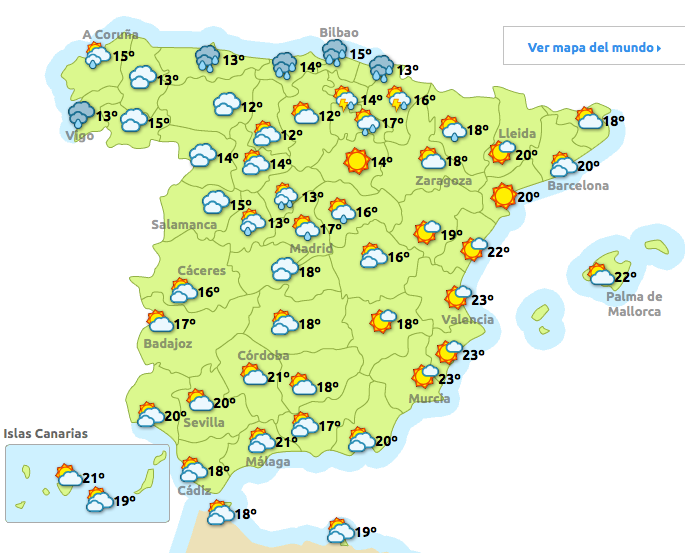
En la jornada del jueves las precipitaciones se centrarán en el norte y centro peninsular,siendo má sfuertes y tormentosas en el nordeste, y sobre todo durante la tarde. Hacia el sur se espera que el tiempo mejore, con cielos aún nubosos, aunque ya con baja probabilidad de precipitaciones. Las temperaturas diurnas bajan en el norte, mientras que en el extremo sur y en la zona de Levante tenderán a subir.

NEAR EAST COAST OF HONSHU, JAPAN-4.5

Bild
Magnitude mb 4.5 Region NEAR EAST COAST OF HONSHU, JAPAN Date time 2015-04-16 07:38:50.1 UTC Location 36.72 N ; 140.78 E Depth 46 km Distances 135 km NE of Saitama, Japan / pop: 1,193,350 / local time: 16:38:50.1 2015-04-16 52 km NE of Mito-shi, Japan / pop: 246,538 / local time: 16:38:50.1 2015-04-16 6 km E of Takahagi, Japan / pop: 33,576 / local time: 16:38:50.1 2015-04-16 Source parameters not yet reviewed by a seismologist More information at:   USGS/NEIC Denver, USA   GeoForschungsZentrum (GEOFON) Potsdam, Germany

GERMANY-3.3

Bild
Magnitude ML 3.3 Region GERMANY Date time 2015-04-16 06:38:08.2 UTC Location 51.42 N ; 12.18 E Depth 20 km Distances 149 km SW of Berlin, Germany / pop: 3,426,354 / local time: 08:38:08.2 2015-04-16 90 km SE of Magdeburg, Germany / pop: 229,826 / local time: 08:38:08.2 2015-04-16 16 km NW of Leipzig, Germany / pop: 504,971 / local time: 08:38:08.2 2015-04-16 2 km E of Großkugel, Germany / pop: 2,272 / local time: 08:38:08.2 2015-04-16 Source parameters reviewed by a seismologist   More information at:   Bundesanstalt für Geowissenschaften und Rohstoffe Hannover/Erlangen, Germany   Landesamt fuer Geologie, Rohstoffe und Bergbau Baden-Wuerttemberg, Germany

Risiko für Weinreben: Französische Behörden finden eingeschlepptes Feuer...

Bild
Manche Olivenbäume sind hunderte Jahre alt, doch nun sollen sie fallen. Die Behörden in Süditalien versuchen auf Betreiben der EU, die Ausbreitung einer Seuche zu verhindern, die dort viele Haine befallen hat. Die Aufregung unter Olivenproduzenten ist groß. Nun haben auch französische Behörden die Seuche nahe Paris entdeckt, in einer Pflanze, die über Rotterdam aus Costa Rica importiert wurde. Die Regierung diskutiert nun verschiedene Schutzmaßnahmen, denn die wirtschaftlichen Folgen der Einsch… LESEN SIE MEHR: http://de.euronews.com/2015/04/15/ris...

Sandsturm im Norden Chinas

Bild
Über den Norden Chinas ist ein schwerer Sandsturm hinweggefegt. In mehreren Städten führte er zu starken Sicht- und Verkehrsbehinderungen. In Peking verfärbte sich die Skyline orange. Fahrzeuge schalteten Nebelscheinwerfer ein, um überhaupt noch Sicht zu haben. Viele Fußgänger legten Atemschutzmasken an, um sich vor dem Staub zu schützen. Auch in der benachbarten Provinz Hebei kam es zum ersten Sandturm dieses Jahres. Die Sichtweite war auf 700 Meter begrenzt. Es kam zu Stromausfällen, Verkehrsc… LESEN SIE MEHR: http://de.euronews.com/2015/04/15/san...

Vulkanausbruch in Peru: Schlammlawine schneidet Stadt von Außenwelt ab

Bild
Im Südwesten Perus ist der Vulkan Ubinas erwacht. Der Berg stößt Rauch, Lava und Asche aus. Perú: Explosión hoy del volcán #Ubinas lanza Fumarola a 3.5km de altura. Vía @DiscloseR1 VIDEO http://t.co/o6L5vPwtLb pic.twitter.com/mlWsCvIrEU— Geól. Sergio Almazán (@chematierra) 15. April 2015 Schlammlawinen versperren den Zugang zur Stadt Ubinas am Fuße des Berges. Video: peligroso descenso de un lahar (flujo de lodo) en el volcán Ubinas, Perú. http://t.co/0WAPhawVKZ pic.twitte… LESEN SIE MEHR: http://de.euronews.com/2015/04/16/vul...

EL HIERRO-FRONTERA.IHI-2.0

Bild
Evento Fecha Hora (GMT)* Latitud Longitud Prof. (km) Int. (***) Máx. Mag. Tipo (**) Mag. Localización 1325410 16/04/2015 02:39:03 27.7634 -18.1526 28   2.0 4 W FRONTERA.IHI

ORAN.ALGERIA-2.1

Bild
Evento Fecha Hora (GMT)* Latitud Longitud Prof. (km) Int. (***) Máx. Mag. Tipo (**) Mag. Localización 1325414 16/04/2015 04:40:36 35.9243 -0.3923     2.1 4 NE ORAN.ARG

CYPRUS REGION-3.0

Bild
Magnitude ML 3.0 Region CYPRUS REGION Date time 2015-04-16 01:47:32.0 UTC Location 34.44 N ; 32.18 E Depth 25 km Distances 135 km SW of Nicosia, Cyprus / pop: 200,452 / local time: 04:47:32.0 2015-04-16 42 km SW of Paphos, Cyprus / pop: 35,961 / local time: 04:47:32.0 2015-04-16 Source parameters reviewed by a seismologist More information at:   Geological Survey Department Lefkosia, Cyprus

BOSNIA AND HERZEGOVINA-3.2

Bild
Magnitude ML 3.2 Region BOSNIA AND HERZEGOVINA Date time 2015-04-16 02:08:08.2 UTC Location 43.72 N ; 18.58 E Depth 2 km Distances 23 km SE of Sarajevo, Bosnia and Herzegovina / pop: 696,731 / local time: 04:08:08.2 2015-04-16 10 km S of Koran, Bosnia and Herzegovina / pop: 3,395 / local time: 04:08:08.2 2015-04-16 Source parameters reviewed by a seismologist  

OFFSHORE SUCRE, VENEZUELA-5.2

Bild
Magnitude mb 5.2 Region OFFSHORE SUCRE, VENEZUELA Date time 2015-04-16 02:24:17.4 UTC Location 10.85 N ; 62.51 W Depth 80 km Distances 111 km W of Port-of-Spain, Trinidad and Tobago / pop: 49,031 / local time: 22:24:17.4 2015-04-15 38 km NW of Güiria, Venezuela / pop: 40,000 / local time: 21:54:17.4 2015-04-15 Source parameters reviewed by a seismologist  

SAN FRANCISO BAY-EARTHQUAKES RISK +5.0 IS LIKELY NEXT 48 HOURS

Bild

GREATER LOS ANGELES AREA, CALIFORNIA-3.2

Bild
Magnitude ML 3.2 Region GREATER LOS ANGELES AREA, CALIF. Date time 2015-04-16 03:59:58.5 UTC Location 34.33 N ; 118.46 W Depth 9 km Distances 37 km NW of Los Angeles, United States / pop: 3,792,621 / local time: 20:59:58.5 2015-04-15 6 km N of San Fernando, United States / pop: 23,645 / local time: 20:59:58.5 2015-04-15 Source parameters provided by:   Southern California Seismic Network, California Institute of Technology / USGS - Pasadena -- , USA (CI)

ROMANIA-3.2-3.3

Bild
Magnitude ML 3.2 Region ROMANIA Date time 2015-04-16 06:27:37.9 UTC Location 45.10 N ; 25.33 E Depth 17 km Distances 96 km NW of Bucharest, Romania / pop: 1,877,155 / local time: 09:27:37.9 2015-04-16 21 km NW of Târgovişte, Romania / pop: 88,435 / local time: 09:27:37.9 2015-04-16 4 km SE of Bărbuleţu, Romania / pop: 6,777 / local time: 09:27:37.9 2015-04-16 Source parameters provided by: Magnitude ML 3.3 Region ROMANIA Date time 2015-04-16 03:19:51.0 UTC Location 45.75 N ; 26.62 E Depth 86 km Distances 152 km N of Bucharest, Romania / pop: 1,877,155 / local time: 06:19:51.0 2015-04-16 44 km W of Focşani, Romania / pop: 105,112 / local time: 06:19:51.0 2015-04-16 8 km SW of Paltin, Romania / pop: 3,687 / local time: 06:19:51.0 2015-04-16 Source parameters provided by:   National Institute for Earth Physics -- Bucharest, Romania (BUC)