Posts

Es werden Posts vom Januar 13, 2024 angezeigt.

2 km N of Caravaca,-71 km WNW of Murcia-1.5

Magnitude 1.5 Region SPAIN Date time 2024-01-13 22:40:10.9 UTC Location 38.300 ; -1.838 Depth 0 km Distance 71 km WNW of Murcia, Spain / pop: 436,000 / local time: 23:40:10.9 2024-01-13 22 km N of Caravaca, Spain / pop: 26,400 / local time: 23:40:10.9 2024-01-13 Source parameters provided by: Instituto Geografico Nacional -- Madrid, Spain (IGN) Global view I felt this earthquake All data providers for this event: Instituto Geografico Nacional -- Madrid, Spain (IGN) Further information can be found at: Instituto Geografico Nacional -- Madrid, Spain (IGN)
GALICIA-CABANA DE BERGANTIÑOS.A CORUÑA-2.0

es2024axhki 13/01/2024 17:47:59 18:47:59 43.1750 -8.8522 6.0 2.0 mbLg SE CABANA DE BERGANTIÑOS.C

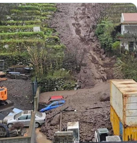
Un deslizamiento de tierra sepulta tres vehículos en la zona de Fajã dos Cardos, municipio de Curral das Freiras, en la isla de Madeira, Portugal 🇵🇹 (12-01-2024).

Bild
entinela35 @Centinela_35 Un deslizamiento de tierra sepulta tres vehículos en la zona de Fajã dos Cardos, municipio de Curral das Freiras, en la isla de Madeira, Portugal 🇵🇹 (12-01-2024). https://dnoticias.pt/2024/1/13/3899

GALICIA-14 km WSW of Carballo-43 km SW of A Coruña,-2.1

Magnitude 2.1 Region SPAIN Date time 2024-01-13 17:47:59.2 UTC Location 43.175 ; -8.852 Depth 6 km Distance 43 km SW of A Coruña, Spain / pop: 246,000 / local time: 18:47:59.2 2024-01-13 14 km WSW of Carballo, Spain / pop: 30,900 / local time: 18:47:59.2 2024-01-13 Source parameters provided by: Instituto Geografico Nacional -- Madrid, Spain (IGN) Global view I felt this earthquake All data providers for this event: Instituto Geografico Nacional -- Madrid, Spain (IGN) Further information can be found at: Instituto Geografico Nacional -- Madrid, Spain (IGN)

Ich backe Brot ohne Strom, Backofen und Herd! Der Krieg in meinem Land h...

Bild
https://youtu.be/9I9lDgWtTFs?si=e_YUKDS62dQY2lT3

JAN MAYEN ISLAND REGION-768 km W of Leknes, Norway-4.8

Magnitude 4.8 Region JAN MAYEN ISLAND REGION Date time 2024-01-13 01:27:23.3 UTC Location 71.475 ; -4.042 Depth 10 km Distance 1059 km N of Tórshavn, Faroe Islands / pop: 13,200 / local time: 01:27:23.3 2024-01-13 768 km W of Leknes, Norway / pop: 3,500 / local time: 02:27:23.3 2024-01-13 Source parameters provided by: National Earthquake Information Center, U.S. Geological Survey -- Golden, United States (NEIC) Global view I felt this earthquake All data providers for this event: Seismological Survey of Serbia -- Belgrade, Serbia (BEO) ELKH EPSS Kovesligetyh rado Seismological Observatory -- Budapest, Hungary (BUD) GeoForschungsZentrum (GFZ) -- Potsdam, Germany (GFZ) Instituto Portugues do Mar e da Atmosfera -- Lisbon, Portugal (IPMA) Ukrainian NDC, Main Center of Special Monitoring -- Kyiv, Ukraine (MCSM) Malta Seismic Network, Seismic Monitoring and Research Unit (SMRU), University of Malta -- Imsida, Malta (MLT) National Earthquake Information Center, U.S. Geological Survey -- Go

11 km E of Waidring, Austria-3.0

Magnitude 3.0 Region AUSTRIA Date time 2024-01-13 01:58:29.3 UTC Location 47.555 ; 12.711 Depth 10 km Distance 37 km SSW of Salzburg, Austria / pop: 153,000 / local time: 02:58:29.3 2024-01-13 11 km E of Waidring, Austria / pop: 2,000 / local time: 02:58:29.3 2024-01-13 Source parameters not yet reviewed by a seismologist Global view I felt this earthquake All data providers for this event: Geophysical Institute of the Academy of Sciences -- Prague, Czech Republic (GFU) GeoForschungsZentrum (GFZ) -- Potsdam, Germany (GFZ) Instituto Nazionale di Geofisica e Vulcanologia -- Rome, Italy (INGV) Slovenian Environment Agency, Seismology Office -- Ljubljana, Slovenia (ARSO) GeoSphere Austria -- Vienna, Austria (GSA) Further information can be found at: Bundesanstalt fur Geowissenschaften und Rohstoffe, German Regional Seismograph Network -- Hannover, Germany (BGR) Landsamt fur Geologie, Rohstoffe und Bergbau -- Freiburg, Germany (LED) GeoSphere Austria -- Vienna, Austria (GSA)

LALÍN.PONTEVEDRA-1.9

Bild
es2024avmbd 12/01/2024 17:52:49 18:52:49 42.6408 -8.0800 15.0 1.9 mbLg SE LALÍN.PO

14 km WSW of Gătaia, Romania-3.6

Magnitude 3.6 Region ROMANIA Date time 2024-01-13 09:08:27.4 UTC Location 45.430 ; 21.247 Depth 0 km Distance 36 km SSE of Timişoara, Romania / pop: 315,000 / local time: 11:08:27.4 2024-01-13 14 km WSW of Gătaia, Romania / pop: 8,000 / local time: 11:08:27.4 2024-01-13 Source parameters not yet reviewed by a seismologist Global view I felt this earthquake All data providers for this event: Seismological Survey of Serbia -- Belgrade, Serbia (BEO) National Institute for Earth Physics -- Bucharest, Romania (NIEP) ELKH EPSS Kovesligetyh rado Seismological Observatory -- Budapest, Hungary (BUD) Geophysical Institute of the Academy of Sciences -- Prague, Czech Republic (GFU) GeoForschungsZentrum (GFZ) -- Potsdam, Germany (GFZ) Ukrainian NDC, Main Center of Special Monitoring -- Kyiv, Ukraine (MCSM) Further information can be found at: National Institute for Earth Physics -- Bucharest, Romania (NIEP) Seismological Survey of Serbia -- Belgrade, Serbia (BEO)