Posts

Es werden Posts vom August 30, 2015 angezeigt.

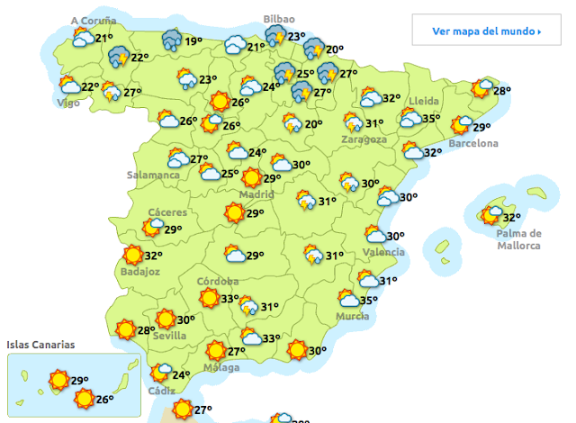
Das Wetter am Montag-31-08-2015

Bild

LA ALBERCA DE ZÁNCARA.CUENCA-1.8

Bild
Evento Fecha Hora (GMT)* Latitud Longitud Prof. (km) Int. (***) Máx. Mag. Tipo (**) Mag. Localización 1342176 30/08/2015 20:20:17 39.4822 -2.5370     1.8 4 SW LA ALBERCA DE ZÁNCARA.CU Ampliar   Fases

NEPAL-4.7

Bild
You felt this earthquake. Tell us! Magnitude mb 4.7 Region NEPAL Date time 2015-08-30 13:17:33.9 UTC Location 27.61 N ; 85.62 E Depth 10 km Distances 31 km E of Kathmandu, Nepal / pop: 1,442,271 / local time: 19:02:33.9 2015-08-30 10 km E of Banepa, Nepal / pop: 17,153 / local time: 19:02:33.9 2015-08-30 Source parameters reviewed by a seismologist More information at:   National Seismological Centre Kathmandu, Nepal   USGS/NEIC Denver, USA   GeoForschungsZentrum (GEOFON) Potsdam, Germany

GUERRERO, MEXICO-4.1

Bild
You felt this earthquake. Tell us! Magnitude mb 4.1 Regi G You felt this earthquake. Tell us! Magnitude mb 4.1 Region GUERRERO, MEXICO Date time 2015-08-30 13:56:44.5 UTC Location 17.07 N ; 100.37 W Depth 10 km Distances 288 km SW of Iztapalapa, Mexico / pop: 1,820,888 / local time: 08:56:44.5 2015-08-30 107 km SW of Chilpancingo de los Bravos, Mexico / pop: 165,250 / local time: 08:56:44.5 2015-08-30 4 km W of Zacualpan, Mexico / pop: 4,100 / local time: 08:56:44.5 2015-08-30 Source parameters provided by:   National Earthquake Information Center, U.S. Geological Survey -- Golden, USA (NEIR) More information at:   USGS/NEIC Denver, USA   GeoForschungsZentrum (GEOFON) Potsdam, Germany

NORTHERN COLOMBIA-4.4

Bild
You felt this earthquake. Tell us! Magnitude mb 4.4 Region NORTHERN COLOMBIA Date time 2015-08-30 15:13:12.3 UTC Location 6.96 N ; 73.16 W Depth 141 km Distances 277 km E of Medellín, Colombia / pop: 1,999,979 / local time: 10:13:12.3 2015-08-30 19 km S of Bucaramanga, Colombia / pop: 571,820 / local time: 10:13:12.3 2015-08-30 Source parameters provided by:   National Earthquake Information Center, U.S. Geological Survey -- Golden, USA (NEIR) More information at:   USGS/NEIC Denver, USA   GeoForschungsZentrum (GEOFON) Potsdam, Germany

NORTHEASTERN IRAN-4.9

Bild
You felt this earthquake. Tell us! Magnitude mb 4.9 Region NORTHEASTERN IRAN Date time 2015-08-30 14:38:43.4 UTC Location 37.09 N ; 57.90 E Depth 10 km Distances 105 km SW of Ashgabat, Turkmenistan / pop: 727,700 / local time: 19:38:43.4 2015-08-30 66 km SE of Bojnūrd, Iran / pop: 192,041 / local time: 19:08:43.4 2015-08-30 35 km E of Esfarāyen, Iran / pop: 59,678 / local time: 19:08:43.4 2015-08-30 Source parameters reviewed by a seismologist More information at:   Institute of Geophysics, University of Tehran Tehran, Iran   International Institute of Earthquake Engineering and Seismology Tehran, Iran   Geophysical Survey. Russian Academy of Sciences Obninsk, Russia

SOUTHERN GREECE-4.4

Bild
You felt this earthquake. Tell us! Magnitude ML 4.4 Region SOUTHERN GREECE Date time 2015-08-30 13:28:02.7 UTC Location 37.83 N ; 21.34 E Depth 21 km Distances 210 km W of Athens, Greece / pop: 729,137 / local time: 16:28:02.7 2015-08-30 58 km SW of Pátra, Greece / pop: 163,360 / local time: 16:28:02.7 2015-08-30 19 km NW of Pýrgos, Greece / pop: 22,399 / local time: 16:28:02.7 2015-08-30 4 km E of Savália, Greece / pop: 1,339 / local time: 16:28:02.7 2015-08-30 Source parameters provided by:     Aristotle University of Thessaloniki, Department of Geophysics -- Thessaloniki, Greece (THE) More information at:   National Observatory of Athens, Geodynamic Institute Athens, Greece   Department of Geophysics, University of Thessaloniki Thessaloniki, Greece   University of Patras, Seismological Laboratory Patras, Greece
Karibik: Wirbelsturm "Erika" zieht Richtung Florida

Bild
Veröffentlicht am 30.08.2015 Wirbelsturm «Erika» hat bei seinem Zug durch die Karibik mindestens 35 Menschen getötet und eine Spur der Verwüstung hinterlassen. Am härtesten betroffen war bislang der östliche Inselstaat Dominica, wo die Zahl der Toten noch weiter steigen könnte. Zahlreiche Menschen werden nach den Unwettern vermisst. Erwartet wird, dass der Wirbelsturm am Wochenende weiter in Richtung Nordwesten zieht und sich der US-Küste nähert. Der US- Wetterdienstes NWS erwartet im Süden des Staates Florida heftigen … LESEN SIE MEHR: http://de.euronews.com/2015/08/29/kar...

French motorway remains closed after travellers end blockade

Bild
Veröffentlicht am 29.08.2015 A group of travellers who blocked one of Europe's busiest motorways in northern France have ended their protest after the authorities gave in to their demands. The barriers were lifted on the A1 at Roye about 100 kilometres north of Paris late on Saturday morning. But the road was expected to remain closed until 19.00 CET to allow for repairs. #A1 sens Paris/Lille réouverture totale à compter de 19h00 @Somme_fr @sanef_autoroute— Préfète de la Somme (@PrefectureSomme) August 29, 2… READ MORE : http://www.euronews.com/2015/08/29/fr...

US: Erika downgraded from tropical storm, but still poses flood threat

Bild
Veröffentlicht am 30.08.2015 The US National Hurricane Center has downgraded "Tropical Storm Erika": http://www.euronews.com/2015/08/28/fl... . Its maximum sustained winds have dropped to 56km per hour, which is just below the tropical storm threshold. However, experts warn wind gusts and flash floods still pose a threat. … READ MORE : http://www.euronews.com/2015/08/29/us...

BERIÁIN-PAMPLONA-NAVARRA-1.8

Bild
Evento Fecha Hora (GMT)* Latitud Longitud Prof. (km) Int. (***) Máx. Mag. Tipo (**) Mag. Localización 1342116 29/08/2015 19:22:29 42.7280 -1.6757     1.8 4 W BERIÁIN.NA

E CALVARRASA DE ARRIBA.SALAMANCA-1.8

Bild
Evento Fecha Hora (GMT)* Latitud Longitud Prof. (km) Int. (***) Máx. Mag. Tipo (**) Mag. Localización 1342149 29/08/2015 21:52:06 40.9118 -5.5645 15   1.8 4 E CALVARRASA DE ARRIBA.SA

CABO DE SAN VICENTE-2.4-2.3

Bild
Evento Fecha Hora (GMT)* Latitud Longitud Prof. (km) Int. (***) Máx. Mag. Tipo (**) Mag. Localización 1342153 30/08/2015 04:16:19 36.9044 -11.0541     2.4 4 SW CABO DE SAN VICENTE Evento Fecha Hora (GMT)* Latitud Longitud Prof. (km) Int. (***) Máx. Mag. Tipo (**) Mag. Localización 1342154 30/08/2015 05:24:27 36.7301 -9.7317 20   2.3 4 SW CABO DE SAN VICENTE

CATALUNYA-MASARAC.GIRONA-1.6

Bild
Evento Fecha Hora (GMT)* Latitud Longitud Prof. (km) Int. (***) Máx. Mag. Tipo (**) Mag. Localización 1342151 30/08/2015 03:25:39 42.3318 2.9825     1.6 4 SE MASARAC.GI