Posts

Es werden Posts vom November 18, 2015 angezeigt.

SOUTHERN XINJIANG, CHINA-4.4

Bild
You felt this earthquake. Tell us! Magnitude mb 4.4 Region SOUTHERN XINJIANG, CHINA Date time 2015-11-18 20:54:40.6 UTC Location 40.17 N ; 77.12 E Depth 1 km Distances 342 km S of Almaty, Kazakhstan / pop: 2,000,900 / local time: 02:54:40.6 2015-11-19 169 km SE of Naryn, Kyrgyzstan / pop: 52,300 / local time: 02:54:40.6 2015-11-19 126 km NE of Kashi, China / pop: 274,717 / local time: 02:54:40.6 2015-11-19 Source parameters provided by:   Kazakhstan National Data Center -- Almaty, Kazakhstan (NNC) More information at:   Kazakhstan National Data Center, Institute of Geophysical Research Almaty, Kazakhstan   USGS/NEIC Denver, USA   GeoForschungsZentrum (GEOFON) Potsdam, Germany   Geophysical Survey. Russian Academy of Sciences Obninsk, Russia
LIVE Ryanair #FR8183 from Fuerteventura to London is diverting to Nantes.

Bild
LIVE Ryanair #FR8183 from Fuerteventura to London is diverting to Nantes. 6 hours ago

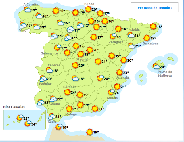
Das Wetter am Donnerstag-19-11-2015-El tiempo jueves

Bild

Atentados en París afectan a aerolíneas y hoteles de España

Bild
Veröffentlicht am 18.11.2015 Compañías de aerolíneas y hoteleras españolas registrarían una baja de ingresos tras los ataques terroristas del pasado 13 de noviembre en París. Este impacto negativo podría ser pasajero en el sector turístico, además de que podría afectar el turismo de negocios, ocio y restauración. teleSUR http://multimedia.telesurtv.net/v/ate...

Carlos Deza ‏@CarlosDezaDeza -Actualizando.

Bild
Carlos Deza ‏ @ CarlosDezaDeza 17m 17 minutes ago Actualizando.

CAUTERETS.FRANCE-2.1

Bild
Evento Fecha Hora (GMT)* Latitud Longitud Prof (km) Int. (***) Máx. Mag Tipo (**) Mag. Localización 1354939 18/11/2015 17:51:03 42.8874 -0.2661     2.1 4 W CAUTERETS.FRA

Very deep low , stormlow could strike West Europe next week ! 950mb , could be a super storm !

Bild
Ryan/J-Ashoka ‏ @ WinterExpert 18m 18 minutes ago @ WinterExpert Very deep low , stormlow could strike West Europe next week ! 950mb , could be a super storm !

12z ECMWF run+192h possible a super storm on his way towards Ireland/UK/Netherlands !

Bild
  Ryan/J-Ashoka ‏ @ WinterExpert 15m 15 minutes ago 12z ECMWF run+192h possible a super storm on his way towards Ireland/UK/Netherlands !

Espectaculars virgues a la posta. #Gava.

Bild
  ARA Méteo Retweeted Xavi Cabo Papiol ‏ @ xavicabopapiol 37m 37 minutes ago @ TomasMolinaB @ gemmapuigf @ MeteoMauri # 324eltemps @ ARAmeteo @ AEMET_Cat Espectaculars virgues a la posta. # Gava .

Hasta el día 20 incluido, el anticiclón reinará sobre la Península; al día siguiente cambio brusco del tiempo

Bild
AEMET ‏ @ AEMET_Esp 6h 6 hours ago Hasta el día 20 incluido, el anticiclón reinará sobre la Península; al día siguiente cambio brusco del tiempo

CANARY ISLANDS, SPAIN REGION-Fuencaliente de la Palma-2.9

Bild
You felt this earthquake. Tell us! Magnitude ML 2.9 Region CANARY ISLANDS, SPAIN REGION Date time 2015-11-18 15:06:49.8 UTC Location 27.77 N ; 18.22 W Depth 33 km Distances 500 km W of Laâyoune / El Aaiún, Western Sahara / pop: 188,084 / local time: 15:06:49.8 2015-11-18 208 km W of Santa Cruz de Tenerife, Spain / pop: 222,417 / local time: 15:06:49.8 2015-11-18 88 km SW of Fuencaliente de la Palma, Spain / pop: 1,894 / local time: 15:06:49.8 2015-11-18 Source parameters provided by: Evento Fecha Hora (GMT)* Latitud Longitud Prof (km) Int. (***) Máx. Mag Tipo (**) Mag. Localización 1354934 18/11/2015 15:06:49 27.7653 -18.2229 33   2.9 4 W FRONTERA.IHI     Instituto Geografico Nacional -- Madrid, Spain (MAD) More information at:   Instituto Geografico Nacional M...

Two Air France flights from U.S. diverted by bomb threats

Bild
Reuters Top News ‏ @ Reuters 8m 8 minutes ago Two Air France flights from U.S. diverted by bomb threats http:// reut.rs/1SXBjyx  

Mínimas de esta madrugada. El valor más bajo se ha registrado en #PuertoElPico, #Ávila, -4,3ºC

Bild
AEMET ‏ @ AEMET_Esp 1h 1 hour ago Mínimas de esta madrugada. El valor más bajo se ha registrado en # PuertoElPico , # Ávila , -4,3ºC

CAUTERETS.FRANCE-2.2

Bild
Evento Fecha Hora (GMT)* Latitud Longitud Prof (km) Int. (***) Máx. Mag Tipo (**) Mag. Localización 1354578 17/11/2015 16:08:42 42.9689 -0.1186 3   2.2 4 N CAUTERETS.FRA

CATALUNYA-COSTA BRAVA-NE L' ESCALA.GIRONA-1.5

Bild
Evento Fecha Hora (GMT)* Latitud Longitud Prof (km) Int. (***) Máx. Mag Tipo (**) Mag. Localización 1354631 18/11/2015 01:53:49 42.1801 3.1736     1.5 4 NE L' ESCALA.GI

ISLA CANARIAS-EL HIERRO-FRONTERA.IHI-2.4

Bild
Evento Fecha Hora (GMT)* Latitud Longitud Prof (km) Int. (***) Máx. Mag Tipo (**) Mag. Localización 1354660 18/11/2015 04:44:07 27.7614 -18.2437 34   2.4 4 W FRONTERA.IHI

ISLA CANARIA-Lanzarote-YAIZA.ILZ-2.1

Bild
Evento Fecha Hora (GMT)* Latitud Longitud Prof (km) Int. (***) Máx. Mag Tipo (**) Mag. Localización 1354669 18/11/2015 06:06:59 29.0351 -13.7944     2.1 4 NW YAIZA.ILZ

GREECE-4.5

Bild
You felt this earthquake. Tell us! Magnitude ML 4.5 Region GREECE Date time 2015-11-18 05:18:15.1 UTC Location 38.53 N ; 20.39 E Depth 5 km Distances 297 km W of Athens, Greece / pop: 729,137 / local time: 07:18:15.1 2015-11-18 122 km W of Pátra, Greece / pop: 163,360 / local time: 07:18:15.1 2015-11-18 40 km N of Argostólion, Greece / pop: 9,820 / local time: 07:18:15.1 2015-11-18 Source parameters reviewed by a seismologist More information at:   National Observatory of Athens, Geodynamic Institute Athens, Greece   Department of Geophysics, University of Thessaloniki Thessaloniki, Greece   University of Patras, Seismological Laboratory Patras, Greece

Alemania evacua el estadio de Hannover tras recibir información sobre "una amenaza concreta"

Noticias Información ‏ @ AreadeNoticias 22m 22 minutes ago Alemania evacua el estadio de Hannover tras recibir información sobre "una amenaza concreta" http:// bit.ly/1X5L6mv   # noticias # mundo

Das Wetter am Mittwoch-18-11-2015-El tiempo Miercoles

Bild

FRANCE-Jausiers-2.4

Bild
You felt this earthquake. Tell us! Magnitude ML 2.4 Region FRANCE Date time 2015-11-17 18:21:36.6 UTC Location 44.47 N ; 6.76 E Depth 2 km Distances 97 km NW of Monaco, Monaco / pop: 32,965 / local time: 19:21:36.6 2015-11-17 55 km E of Gap, France / pop: 42,715 / local time: 19:21:36.6 2015-11-17 6 km N of Jausiers, France / pop: 1,026 / local time: 19:21:36.6 2015-11-17 Source parameters provided by:   Laboratoire de Détection et de Géophysique -- Bruyères-le-Châtel, France (LDG) More information at:   Italian National Seismic Network Roma, Italy   Laboratoire de Détection et de Géophysique Bruyères-le-Châtel, France   GéoAzur Sofia-Antipolis, France   Réseau National de Surveillance Sismique Strasbourg, France   Bureau Central Sismologique Francais (BCSF) Strasbourg, France   Plan Séisme ( Information sur les bons gestes à appliquer en cas de séisme )

SOUTHERN QINGHAI, CHINA-4.9

Bild
You felt this earthquake. Tell us! Magnitude mb 4.9 Region SOUTHERN QINGHAI, CHINA Date time 2015-11-17 22:15:29.2 UTC Location 32.05 N ; 95.00 E Depth 10 km Distances 726 km NE of Thimphu, Bhutan / pop: 98,676 / local time: 04:15:29.2 2015-11-18 458 km NE of Lhasa, China / pop: 118,721 / local time: 06:15:29.2 2015-11-18 233 km NW of Qamdo, China / pop: 86,280 / local time: 06:15:29.2 2015-11-18 Source parameters not yet reviewed by a seismologist More information at:   USGS/NEIC Denver, USA   GeoForschungsZentrum (GEOFON) Potsdam, Germany