Posts

Es werden Posts vom Oktober 21, 2016 angezeigt.

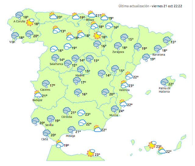
Das Wetter am Samstag-22-10-2016-El tiempo sábado-19 Avisos

Bild
19 Avisos Ávila 2 Badajoz 1 Barcelona 1 Cáceres 4 Cádiz 1 Ciudad Real 1 Girona 1 Huelva 2 Salamanca 2 Sevilla 1 Toledo 1 Menorca 1 Mallorca 1

Andreas Popp - Es sieht übel aus

Bild
Publicado el 19 mar. 2016 Quelle: http://youtu.be/xYc5Yz4t5Wo http://www.youtube.com/user/MMnewsTV http://www.youtube.com/user/Wissensma...

AZORES ISLANDS REGION-3.4

Bild
You felt this earthquake. Tell us! Magnitude ML 3.4 Region AZORES ISLANDS REGION Date time 2016-10-21 19:04:20.0 UTC Location 37.45 N ; 24.57 W Depth 5 km Distances 1360 km W of Lisbon, Portugal / pop: 518,000 / local time: 20:04:20.0 2016-10-21 102 km E of Ponta Delgada, Portugal / pop: 20,100 / local time: 19:04:20.0 2016-10-21 75 km SE of Furnas, Portugal / pop: 1,600 / local time: 19:04:20.0 2016-10-21 Source parameters provided by:   Instituto Português do Mar e Atmosfera -- Azores Delegation, Portugal (PDA) More information at:   Instituto Portugues do Mar e da Atmosfera Azores Delegation, Portugal

IIFF_CV dos fotos mas de #sax esta tarde fotos subidas por ..

Bild
Prevenció d'incendis Retweeted Moran19 ‏ @ Elmoran19 15h 15 hours ago @ Preven_IIFF_CV dos fotos mas de # sax esta tarde fotos subidas por @ IntercomarcalTV

El mapa por riesgo de incendio para hoy 21 de octubre.

Bild
Prevenció d'incendis ‏ @ Preven_IIFF_CV 4h 4 hours ago El mapa por riesgo de incendio para hoy 21 de octubre. Buenos días y buen servicio a todos los medios!

WESTERN HONSHU, JAPAN-6.2-Tsunami information

Bild
  You felt this earthquake. Tell us! Magnitude Mw 6.2 Region WESTERN HONSHU, JAPAN Date time 2016-10-21 05:07:23.4 UTC Location 35.37 N ; 133.73 E Depth 10 km Distances 152 km NW of Kōbe-shi, Japan / pop: 1,529,000 / local time: 14:07:23.4 2016-10-21 48 km W of Tottori, Japan / pop: 155,000 / local time: 14:07:23.4 2016-10-21 11 km SW of Kurayoshi, Japan / pop: 48,400 / local time: 14:07:23.4 2016-10-21 Source parameters reviewed by a seismologist   Tsunami-Information:http:// erdbeben-earthquake-terremoto.blogspot.com/ More information at:   USGS/NEIC Denver, USA   GeoForschungsZentrum (GEOFON) Potsdam, Germany Tsunami information at:   Japan Meteorological Agency   Tokyo, Japan   Pacific Tsunami Warning Centre   Hawai, USA
OFFSHORE CAMPECHE, MEXICO-4.1

Bild
  You felt this earthquake. Tell us! Magnitude mb 4.1 Region OFFSHORE CAMPECHE, MEXICO Date time 2016-10-21 05:38:55.8 UTC Location 19.54 N ; 92.23 W Depth 10 km Distances 445 km NW of Belmopan, Belize / pop: 13,400 / local time: 23:38:55.8 2016-10-20 181 km W of Campeche, Mexico / pop: 206,000 / local time: 00:38:55.8 2016-10-21 109 km N of Ciudad del Carmen, Mexico / pop: 142,000 / local time: 00:38:55.8 2016-10-21 Source parameters provided by:   National Earthquake Information Center, U.S. Geological Survey -- Golden, USA (NEIR)

GULF OF CALIFORNIA-4.1

Bild
  You felt this earthquake. Tell us! Magnitude mb 4.1 Region GULF OF CALIFORNIA Date time 2016-10-21 05:43:37.1 UTC Location 27.86 N ; 111.81 W Depth 26 km Distances 620 km S of Phoenix, United States / pop: 1,446,000 / local time: 22:43:37.1 2016-10-20 157 km SW of Hermosillo, Mexico / pop: 596,000 / local time: 22:43:37.1 2016-10-20 76 km NE of Santa Rosalía, Mexico / pop: 11,900 / local time: 23:43:37.1 2016-10-20 Source parameters provided by:   National Earthquake Information Center, U.S. Geological Survey -- Golden, USA (NEIR)

ATLÁNTICO-CANARIAS-1.9

Bild
Evento Fecha Hora (GMT)* Latitud Longitud Prof (km) Int. (***) Máx. Mag Tipo (**) Mag. Localización es2016mlgln 21/10/2016 00:09:37 28.0933 -16.1611 35   1.9 4 ATLÁNTICO-CANARIAS

LA FONT DE LA FIGUERA.VALENCIA-1.6

Bild
Evento Fecha Hora (GMT)* Latitud Longitud Prof (km) Int. (***) Máx. Mag Tipo (**) Mag. Localización es2016mlhdb 21/10/2016 01:08:27 38.8336 -0.8575 13   1.6 4 NE LA FONT DE LA FIGUERA.V

ISLA CANARIAS-EL HIERRO-FRONTERA.IHI-1.8

Bild
Evento Fecha Hora (GMT)* Latitud Longitud Prof (km) Int. (***) Máx. Mag Tipo (**) Mag. Localización es2016mlibn 21/10/2016 03:08:32 27.7242 -18.1347 14   1.8 4 W FRONTERA.IHI

ATLÁNTICO-GALICIA-1.9

Bild
Evento Fecha Hora (GMT)* Latitud Longitud Prof (km) Int. (***) Máx. Mag Tipo (**) Mag. Localización es2016mljok 21/10/2016 07:02:35 43.3183 -9.7109 12   1.9 4 ATLÁNTICO-GALICIA