Posts

Es werden Posts vom April 10, 2014 angezeigt.

Das Wetter am Freitag

Bild

Kanarische Insel- EL TANQUE.Teneriffa-2.0

Bild
Evento Fecha Hora (GMT)* Latitud Longitud Prof. (km) Int. Máx. Mag. Tipo Mag. (**) Localización 1268071 10/04/2014 15:08:28 28.3191 -16.7602     2.0 4 SE EL TANQUE.ITF

ATLÁNTICO-PORTUGAL-2.4

Bild
Evento Fecha Hora (GMT)* Latitud Longitud Prof. (km) Int. Máx. Mag. Tipo Mag. (**) Localización 1268065 10/04/2014 15:18:52 39.1679 -10.3308 38   2.4 4 ATLÁNTICO-PORTUGAL

FRANCE-2.6

Bild
Magnitude ML 2.6 Region FRANCE Date time 2014-04-10 17:36:28.6 UTC Location 44.47 N ; 6.75 E Depth 2 km Distances 98 km NW of Monaco, Monaco / pop: 32,965 / local time: 19:36:28.6 2014-04-10 54 km E of Gap, France / pop: 42,715 / local time: 19:36:28.6 2014-04-10 6 km N of Jausiers, France / pop: 1,026 / local time: 19:36:28.6 2014-04-10 Source parameters provided by:   Laboratoire de Détection et de Géophysique -- Bruyères-le-Châtel, France (LDG) More information at:   Italian National Seismic Network Roma, Italy   Laboratoire de Détection et de Géophysique Bruyères-le-Châtel, France   GéoAzur Sofia-Antipolis, France   Réseau National de Surveillance Sismique Strasbourg, France   Bureau Central Sismologique Francais (BCSF) Strasbourg, France   Plan Séisme ( Information sur les bons gestes à appliquer en cas de séisme )

Bombenanschlag in Athen

Im Zentrum Athens ist in den frühen Morgenstunden eine Autobombe vor einem Sitz der griechischen Zentralbank explodiert. Verletzt wurde niemand, lediglich Fenster der umliegenden Gebäude gingen zu Bruch. Zwei Unbekannte hatten mit Anrufen bei einer griechischen Zeitung und einem Nachrichtenportal vor der Explosion gewarnt. Ein Passant in Athen sagte: "Natürlich ergibt es keinen Sinn, aber ich glaube, es ist einfach eine Art Protest gegen alles. Es ist nicht richtig, aber was soll ich sagen? Es ... LESEN SIE MEHR: http://de.euronews.com/2014/04/10/bom...

OKLAHOMA-4.1-2.6-2.6-3.3-2.7

Bild
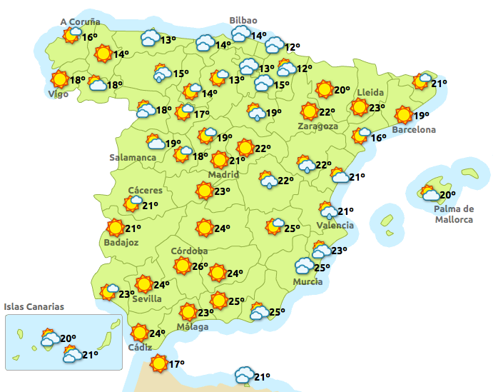
Magnitude mb 4.1 Region OKLAHOMA Date time 2014-04-10 07:33:57.0 UTC Location 35.79 N ; 97.47 W Depth 3 km Distances 339 km N of Dallas, United States / pop: 1,197,816 / local time: 02:33:57.0 2014-04-10 36 km N of Oklahoma City, United States / pop: 579,999 / local time: 02:33:57.0 2014-04-10 11 km S of Guthrie, United States / pop: 10,191 / local time: 02:33:57.0 2014-04-10 Source parameters provided by: Magnitude mb 2.6 Region OKLAHOMA Date time 2014-04-10 06:40:52.0 UTC Location 36.28 N ; 97.27 W Depth 1 km Distances 390 km N of Dallas, United States / pop: 1,197,816 / local time: 01:40:52.0 2014-04-10 93 km N of Oklahoma City, United States / pop: 579,999 / local time: 01:40:52.0 2014-04-10 2 km SE of Perry, United States / pop: 5,126 / local time: 01:40:52.0 2014-04-10 Source parameters provided by: Magnitude mb 2.7 Region OKLAHOMA Date time 2014-04-10 04:26:47.0 UTC Location 36.28 N ; 97.27 W Depth 6 km Distances 390 km N of Dallas, United

Lloret de Mar besorgt wegen russischer Visabeschränkung

Bild
  Gerade für Lloret de Mar ist der Tourismus aus Russland sehr wichtig. Die Zone Fenals zeigt deutliche Abschwächung von russischen Besuchern. Die Worte von Außenminister Jose Manuel Garcia- Margallo vor Monaten, über eine  mögliche Visabeschränkungen für russische Bürger, wurde falsch interpretiert, hieß es aber beschwichtigend, laut der Staatssekretärin für Tourismus, Mary Elizabeth Lamb, am Rathaus Lloret de Mar. Lamm schrieb in einem Brief an den Rat der Stadt Lloret de Mar, über die möglichen Auswirkungen auf den Tourismus, wegen der Aussagen García- Margallo,  das ein Missverständnis  in dieser Hinsicht vorliege. " Durch eine Fehlinterpretation einer Aussage durch das Ministerium, zuständig für verschiedene russische Medien ausgegeben, kam es zu dieser Fehlinformation."  Oder ist doch etwas dran? Vielleicht ist es ein Missverständnis gewesen, oder aber auch Grüße aus Russland vom russischen Präsidenten Putin. Er spielt mit dem Gedanke

Ebola - der bisher schlimmste Ausbruch

Die aktuelle Ebola-Epidemie ist am 9. Februar im westafrikanischen Guinea ausgebrochen. Zwei Monate später hat sie bisher unbekannte Ausmaße erreicht. Die Weltgesundheitsorganisation ist alarmiert. Auf einer Pressekonferenz bezeichnete der zuständige Vizegeneraldirektor der WHO für Gesundheitssicherheit, der Japaner Keiji Fukuda, diesen Ebolaausbruch als den schlimmsten bisher registrierten. Und zwar in erster Linie wegen der großflächigen Verbreitung und zweitens, weil die Krankheit erstmals in... LESEN SIE MEHR: http://de.euronews.com/2014/04/09/ebo...

ALBORÁN NORTE-2.5

Bild
Evento Fecha Hora (GMT)* Latitud Longitud Prof. (km) Int. Máx. Mag. Tipo Mag. (**) Localización 1267954 10/04/2014 04:21:46 36.2580 -3.4030     2.5 4 ALBORÁN NORTE

IZNATE.MALGA-2.7

Bild
Evento Fecha Hora (GMT)* Latitud Longitud Prof. (km) Int. Máx. Mag. Tipo Mag. (**) Localización 1267938 10/04/2014 03:26:37 36.7871 -4.1872 59   2.7 3 NW IZNATE.MA

Gefühltes Beben-CASTELL DE FERRO.GRANADA-2.0-SANTA CRUZ DEL COMERCIO.GR-1.7

Bild
Evento Fecha Hora (GMT)* Latitud Longitud Prof. (km) Int. Máx. Mag. Tipo Mag. (**) Localización 1267853 09/04/2014 20:25:59 36.6467 -3.4225   Sentido 2.0 4 SW CASTELL DE FERRO.GR Evento Fecha Hora (GMT)* Latitud Longitud Prof. (km) Int. Máx. Mag. Tipo Mag. (**) Localización 1267970 10/04/2014 05:12:33 37.1008 -3.9580 9   1.7 4 NE SANTA CRUZ DEL COMERCIO.GR

STRAIT OF GIBRALTAR-2.5-2.7

Bild
Magnitude ML 2.5 Region STRAIT OF GIBRALTAR Date time 2014-04-10 04:21:46.5 UTC Location 36.26 N ; 3.40 W Depth 10 km Distances 176 km E of Gibraltar, Gibraltar / pop: 26,544 / local time: 06:21:46.5 2014-04-10 115 km N of Melilla, Spain / pop: 73,460 / local time: 06:21:46.5 2014-04-10 105 km S of Granada, Spain / pop: 234,325 / local time: 06:21:46.5 2014-04-10 53 km S of El Varadero, Spain / pop: 2,000 / local time: 06:21:46.5 2014-04-10 Source parameters provided by: Magnitude mb 2.7 Region STRAIT OF GIBRALTAR Date time 2014-04-10 03:26:37.0 UTC Location 36.79 N ; 4.19 W Depth 59 km Distances 126 km NE of Gibraltar, Gibraltar / pop: 26,544 / local time: 05:26:37.0 2014-04-10 22 km E of Málaga, Spain / pop: 568,305 / local time: 05:26:37.0 2014-04-10 6 km NE of Valdés, Spain / pop: 13,529 / local time: 05:26:37.0 2014-04-10 Source parameters provided by:   Instituto Geografico Nacional -- Madrid, Spain (MAD) More information at:   Instituto Geografico Nac

NEAR EAST COAST OF HONSHU, JAPAN-4.7

Bild
Magnitude mb 4.7 Region NEAR EAST COAST OF HONSHU, JAPAN Date time 2014-04-10 04:19:04.0 UTC Location 35.70 N ; 140.05 E Depth 75 km Distances 32 km E of Tokyo, Japan / pop: 8,336,599 / local time: 13:19:04.0 2014-04-10 2 km NE of Narashino, Japan / pop: 156,082 / local time: 13:19:04.0 2014-04-10 Source parameters not yet reviewed by a seismologist More information at:   USGS/NEIC Denver, USA   GeoForschungsZentrum (GEOFON) Potsdam, Germany

SOUTHWESTERN RYUKYU ISL., JAPAN-4.8

Bild
Magnitude mb 4.8 Region SOUTHWESTERN RYUKYU ISL., JAPAN Date time 2014-04-10 02:38:05.0 UTC Location 23.82 N ; 123.17 E Depth 30 km Distances 215 km SE of Taipei, Taiwan / pop: 7,871,900 / local time: 10:38:05.0 2014-04-10 160 km E of Hualian, Taiwan / pop: 350,468 / local time: 10:38:05.0 2014-04-10 74 km S of Yonakuni, Japan / pop: 1,684 / local time: 11:38:05.0 2014-04-10 Source parameters not yet reviewed by a seismologist More information at:   USGS/NEIC Denver, USA   GeoForschungsZentrum (GEOFON) Potsdam, Germany