Posts

Es werden Posts vom September 29, 2015 angezeigt.

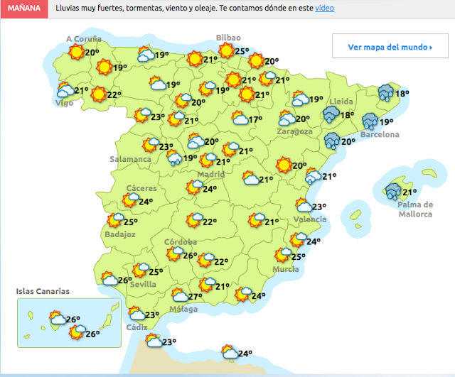
Das Wetter am Mittwoch-Alerta für die Mittelmeerküste-Mallorca

Bild

ALERT Two Southwest Airlines planes collided on the ground at a Seattle Airport

Bild
AirLive.net @ airlivenet ALERT Two Southwest Airlines planes collided on the ground at a Seattle Airport http:// ift.tt/1LZe1D3   pic.twitter.com/OFbfiEalLD

LIVE: Ryanair #FR4502 from Porto has declared an emergency and will divert to Nantes-Francia

LIVE: Ryanair # FR4502 from Porto has declared an emergency and will divert to Nantes pic.twitter.com/kYLKCSNk01 - @ NikPhillips666

Impresionante vídeo de ayer de Rafa Suso de la manga que se vio frente a Santa Pola

Bild
AMETSE ‏ @ MeteoSE 5h 5 hours ago Impresionante vídeo de ayer de Rafa Suso de la manga que se vio frente a Santa Pola https://www. facebook.com/ametsemeteosur este/videos/vb.1386499338250398/1714849115415417/?type=2&theater   … Aquí la Tierra , InfoEmergencias , El Tiempo and 7 others

GOLFO DE CÁDIZ-2.2

Bild
Evento Fecha Hora (GMT)* Latitud Longitud Prof. (km) Int. (***) Máx. Mag. Tipo (**) Mag. Localización 1347012 29/09/2015 00:12:33 36.2029 -7.6343 21   2.2 4 GOLFO DE CÁDIZ Ampliar   Fases

ALHAMA DE MURCIA.MURCIA-2.0

Bild
Evento Fecha Hora (GMT)* Latitud Longitud Prof. (km) Int. (***) Máx. Mag. Tipo (**) Mag. Localización 1347121 29/09/2015 11:29:53 37.8766 -1.5171     2.0 4 W ALHAMA DE MURCIA.MU Ampliar   Fases  * Verano (Hora Oficial = Hora GMT + 2 horas)     Invierno (Hora Oficial = Hora GMT + 1 Hora)     (La hora oficial en Canarias es una hora menos que en el resto de España) ** Ver explicación  Tipo de Magnitud *** Ver explicación  Escala de intensidad Noticias 29/09/2015 Datos Gravimétricos 23/09/2015 Mapas de España 22/09/2015 Cursos Interadministrativos (4º trimestre 2015)

ATLÁNTICO-4.3

Bild
Evento Fecha Hora (GMT)* Latitud Longitud Prof. (km) Int. (***) Máx. Mag. Tipo (**) Mag. Localización 1347153 29/09/2015 12:48:50 41.5341 -15.5416     4.3 3 ATLÁNTICO

American #AA93 to Chicago has diverted to Heathrow

Bild
LIVE: American # AA93 to Chicago has diverted to Heathrow pic.twitter.com/0ttwkFHFAD - @ NikPhillips666

GERMANY-2.3

Bild
You felt this earthquake. Tell us! Magnitude ML 2.3 Region GERMANY Date time 2015-09-29 10:21:40.4 UTC Location 50.35 N ; 7.92 E Depth 3 km Distances 152 km NE of Luxembourg, Luxembourg / pop: 76,684 / local time: 12:21:40.4 2015-09-29 38 km NW of Wiesbaden, Germany / pop: 272,432 / local time: 12:21:40.4 2015-09-29 7 km W of Diez, Germany / pop: 10,822 / local time: 12:21:40.4 2015-09-29 Source parameters provided by:   Landsamt für Geologie, Rohstoffe und Bergbau -- Baden Wuerttemberg, Germany (LED) More information at:   Bundesanstalt für Geowissenschaften und Rohstoffe Hannover/Erlangen, Germany   Landesamt fuer Geologie, Rohstoffe und Bergbau Baden-Wuerttemberg, Germany

CRETE, GREECE-4.7

Bild
You felt this earthquake. Tell us! Magnitude mb 4.7 Region CRETE, GREECE Date time 2015-09-29 09:12:39.9 UTC Location 34.56 N ; 24.48 E Depth 40 km Distances 386 km S of Athens, Greece / pop: 729,137 / local time: 12:12:39.9 2015-09-29 105 km SW of Irákleion, Greece / pop: 137,154 / local time: 12:12:39.9 2015-09-29 89 km S of Réthymnon, Greece / pop: 29,907 / local time: 12:12:39.9 2015-09-29 62 km SW of Tympáki, Greece / pop: 4,923 / local time: 12:12:39.9 2015-09-29 Source parameters reviewed by a seismologist More information at:   Technological Educational Institute of Crete, Seismological Network of Crete Chania, Greece   National Observatory of Athens, Geodynamic Institute Athens, Greece   Department of Geophysics, University of Thessaloniki Thessaloniki, Greece   University of Patras, Seismological Laboratory Patras, Greece
LIVE Real Madrid en-route to Malmo for the Champions League match tomorrow

Bild
AirLive.net @ airlivenet LIVE Real Madrid en-route to Malmo for the Champions League match tomorrow ( @ NikPhillips666 ) http:// live.airlive.net   pic.twitter.com/50DasbAn4A

EMERGENCY Aer Lingus flight #EI110 makes emergency landing with brake fire at JFK Airport

AirLive.net @ airlivenet EMERGENCY Aer Lingus flight # EI110 makes emergency landing with brake fire at JFK Airport http:// ift.tt/1PL1vu7

LIVE KLM #KL1533 AMS-MME is diverting to Newcastle.

Bild
20 m AirLive.net @ airlivenet LIVE KLM # KL1533 AMS-MME is diverting to Newcastle. Track: http:// live.airlive.net   pic.twitter.com/mDkMj95aIE

ALERT: Severe weather to impact air traffic in the Eastern U.S. today

Bild
AirLive.net @ airlivenet ALERT: Severe weather to impact air traffic in the Eastern U.S. today. pic.twitter.com/SJSH0sVVKC - @ AimanJarrar

BREAKING Air France Flight #AF1127 Venice - Paris Is Declaring A Radio Emergency

Bild
AirLive.net @ airlivenet BREAKING Air France Flight # AF1127 Venice - Paris Is Declaring A Radio Emergency http:// planefinder.net/flight/AFR721F  

La magia de la luna en los cielos canarios...

Bild
Meteo RTVC Retweeted lemus photography ‏ @ RodriguLemus 1h 1 hour ago La magia de la luna en los cielos canarios......DELUXE. lemus photography , Vive el Norte , Buscador Canario and 7 others Tenerife Ocio Retweeted TenerifeBonjour ‏ @ TenerifeBonjour 17h 17 hours ago # EclipseLunar # Tenerife (2) @ LoqueveoTfe @ vistoencanarias @ Tenerife_Ocio @ paisajecanario @ nochescanarias @ MeteoRTVC Damián Rodríguez , Julio Alonso , Chiringuito Pirata and 7 others

En lo alto del Teide. A subir¡¡¡

Bild
Teleférico del Teide Retweeted Juan José Castro ‏ @ jucassanchez 18h 18 hours ago En lo alto del Teide. A subir¡¡¡ @ telefericoteide @ EmocionesCan @ canarias_es @ CanariasEnFotos @ paisajecanario

Radar: sobre tierra las únicas precipitaciones en este momento se registran en litoral de Baix Maestrat

Bild
AEMET_C. Valenciana ‏ @ AEMET_CValencia 12m 12 minutes ago Última imagen Radar: sobre tierra las únicas precipitaciones en este momento se registran en litoral de Baix Maestrat

AEGEAN SEA-2.2

Bild
You felt this earthquake. Tell us! Magnitude ML 2.2 Region AEGEAN SEA Date time 2015-09-29 07:43:19.0 UTC Location 39.32 N ; 25.90 E Depth 18 km Distances 147 km NW of İzmir, Turkey / pop: 2,500,603 / local time: 10:43:19.0 2015-09-29 61 km NW of Mytilíni, Greece / pop: 28,322 / local time: 10:43:19.0 2015-09-29 17 km N of Eresós, Greece / pop: 1,042 / local time: 10:43:19.0 2015-09-29 Source parameters provided by:   Kandilli Observatory and Earthquake Research Institute -- Istanbul, Turkey (KAN) More information at:   Disaster and Emergency Management Presidency, Earthquake Department Ankara, Turkey   Kandilli Observatory and Earthquake Research Institute Istanbul, Turkey   National Observatory of Athens, Geodynamic Institute Athens, Greece   Department of Geophysics, University of Thessaloniki Thessaloniki, Greece