Posts

Es werden Posts vom April 28, 2015 angezeigt.

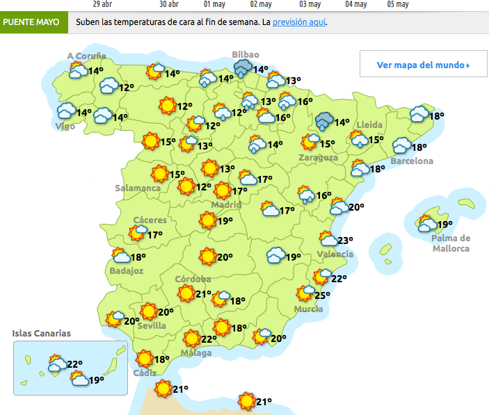
Das Wetter am Mittwoch-29.04.2015

Bild

Nepal: Hoffnung schwindet

Bild
Am dritten Tag nach dem Erdbeben in Nepal schwindet die Hoffnung, noch Überlebende zu finden. Mindestens 4700 Menschen starben. 11.000 sollen verletzt sein. Die Hauptstadt Kathmandu ist stark zerstört. Es regnet. Wer Glück hat, ist in einem Zelt unterkommen. Anil Razssrdes (47) sagt: "Wir haben nichts zu essen, kein Trinkwasser. Wir sitzen hier die ganze Zeit im Zelt. Von der Regierung kommt keine Hilfe." Namrata Adsikron (30) meint: "Viele haben keinen Platz im Zelt bekommen. Sogar Kinder un… LESEN SIE MEHR: http://de.euronews.com/2015/04/28/nep...

WEST OF GIBRALTAR-3.0

Bild
Magnitude ML 3.0 Region WEST OF GIBRALTAR Date time 2015-04-28 20:34:52.0 UTC Location 36.62 N ; 9.72 W Depth 18 km Distances 238 km S of Lisbon, Portugal / pop: 517,802 / local time: 21:34:52.0 2015-04-28 166 km W of Faro, Portugal / pop: 41,355 / local time: 21:34:52.0 2015-04-28 82 km SW of Sagres, Portugal / pop: 1,939 / local time: 21:34:52.0 2015-04-28 Source parameters provided by:   Instituto Português do Mar e da Atmosfera -- Lisbon, Portugal (IMP) More information at:   Instituto Portugues do Mar e da Atmosfera, Seismologia Lisbon, Portugal

HOKKAIDO, JAPAN REGION-4-.5-日本の地震リスク·4月28 日と29--JAPAN EARTHQUAKE RISK-28-29 APRIL

Bild
You felt this earthquake. Tell us! Magnitude mb 4.5 Region HOKKAIDO, JAPAN REGION Date time 2015-04-28 17:49:50.3 UTC Location 43.16 N ; 145.89 E Depth 60 km Distances 370 km E of Sapporo-shi, Japan / pop: 1,883,027 / local time: 02:49:50.3 2015-04-29 31 km SE of Nemuro, Japan / pop: 31,223 / local time: 02:49:50.3 2015-04-29 Source parameters not yet reviewed by a seismologist More information at:   USGS/NEIC Denver, USA   GeoForschungsZentrum (GEOFON) Potsdam, Germany   Geophysical Survey. Russian Academy of Sciences O bninsk, Russia

El Hierro- Canaria Island-EL PINAR.IHI-2.2

Bild
Evento Fecha Hora (GMT)* Latitud Longitud Prof. (km) Int. (***) Máx. Mag. Tipo (**) Mag. Localización 1327153 28/04/2015 18:00:27 27.6618 -18.1364 17   2.2 4 SW EL PINAR.IHI

CABO DE SAN VICENTE -3.1 (Magn.-kann sich ändern)-3.2

Bild
Evento Fecha Hora (GMT)* Latitud Longitud Prof. (km) Int. (***) Máx. Mag. Tipo (**) Mag. Localización ign2015ihip 28/04/2015 20:34:48 36.4875 -9.9901 10   3.1 4 SW CABO DE SAN VICENTE Evento Fecha Hora (GMT)* Latitud Longitud Prof. (km) Int. (***) Máx. Mag. Tipo (**) Mag. Localización 1327172 28/04/2015 20:34:51 36.7180 -9.8563 20   3.2 4 SW CABO DE SAN VICENTE

NORTHERN ALGERIA-3.8-(3.9)

Bild
You felt this earthquake. Tell us! Magnitude ML 3.8 Region NORTHERN ALGERIA Date time 2015-04-28 18:27:30.0 UTC Location 36.98 N ; 3.14 E Depth 10 km Distances 27 km N of Algiers, Algeria / pop: 1,977,663 / local time: 19:27:30.0 2015-04-28 626 km W of Tunis, Tunisia / pop: 693,210 / local time: 19:27:30.0 2015-04-28 629 km S of Andorra la Vella, Andorra / pop: 20,430 / local time: 20:27:30.0 2015-04-28 Source parameters provided by: Evento Fecha Hora (GMT)* Latitud Longitud Prof. (km) Int. (***) Máx. Mag. Tipo (**) Mag. Localización 1327152 28/04/2015 18:27:41 37.2630 2.9645     3.9 3 MEDITERRÁNEO-ARGELIA   Centre de Recherche en Astronomie, Astrophysique et Géophysique -- Algiers, Algeria (CRAA) More information at:   Centre de Recherche en Astronomie, Astrophysique et Géophys

BOSNIA AND HERZEGOVINA-4.1

Bild
You felt this earthquake. Tell us! Magnitude ML 4.1 Region BOSNIA AND HERZEGOVINA Date time 2015-04-28 16:16:50.3 UTC Location 44.55 N ; 17.58 E Depth 10 km Distances 100 km NW of Sarajevo, Bosnia and Herzegovina / pop: 696,731 / local time: 18:16:50.3 2015-04-28 40 km SE of Banja Luka, Bosnia and Herzegovina / pop: 221,106 / local time: 18:16:50.3 2015-04-28 4 km SE of Maslovare, Bosnia and Herzegovina / pop: 4,899 / local time: 18:16:50.3 2015-04-28 Source parameters reviewed by a seismologist More information at:   Republic Hydrometeorological Service, Banja Luka, Republic of Srpska , Bosnia-Herzogovina

OAXACA, MEXICO-5.5

Bild
You felt this earthquake. Tell us! Magnitude Mw 5.5 Region OAXACA, MEXICO Date time 2015-04-28 18:56:54.8 UTC Location 17.15 N ; 94.94 W Depth 114 km Distances 404 km SE of Puebla de Zaragoza, Mexico / pop: 1,590,256 / local time: 13:56:54.8 2015-04-28 189 km E of Oaxaca de Juárez, Mexico / pop: 262,566 / local time: 13:56:54.8 2015-04-28 13 km E of Palomares, Mexico / pop: 4,465 / local time: 13:56:54.8 2015-04-28 Source parameters not yet reviewed by a seismologist More information at:   USGS/NEIC Denver, USA   GeoForschungsZentrum (GEOFON) Potsdam, Germany

FIJI REGION-6.2

Bild
You felt this earthquake. Tell us! Magnitude Mw 6.2 Region FIJI REGION Date time 2015-04-28 16:39:35.5 UTC Location 20.91 S ; 178.60 W Depth 537 km Distances 354 km W of Nuku‘alofa, Tonga / pop: 22,400 / local time: 05:39:35.5 2015-04-29 436 km SE of Suva, Fiji / pop: 77,366 / local time: 04:39:35.5 2015-04-29 1068 km SW of Apia, Samoa / pop: 40,407 / local time: 05:39:35.5 2015-04-29 Source parameters reviewed by a seismologist More information at:   USGS/NEIC Denver, USA   GeoForschungsZentrum (GEOFON) Potsdam, Germany

Hunderte Bergsteiger sitzen weiter am Mount Everest fest

Bild
Am Mount Everest sitzen weiter Hunderte Bergsteiger fest. Die Lawine, die nach dem Erdbeben durch das Basislager fegte, tötete mindestens 17 Menschen und begrub Zelte und anderes Material unter sich. Auch hier ist noch nicht der Verbleib aller Personen geklärt. Zum Zeitpunkt des Erdbebens befanden sich rund 1000 Menschen entlang der Aufstiegsroute. W… LESEN SIE MEHR: http://de.euronews.com/2015/04/28/hun...

Fähre auf der Strecke Palma-Valencia brannte-150 Passagiere evakuiert

Auf der Strecke Palma-Valencia l aut informierten Quellen Salvage, mussten heute 150 Passagiere evakuiert werden. Die Fähre Acciona-Trasmediterranea 'Sorrento' befand sich, etwa 18 Meilen westlich von Mallorca und hatte Feuer gefangen. R asches Eingreifen  und schnelle Koordination ließ die Evakuierung des Schiffes schnell organisieren. Zwei Fähren der Baleària Reederei, die" Visemar I "und" Publia' waren ebenfalls sofort am Ort des Geschens . Das Feuer auf der Fähre Acciona, die um die Mittagszeit den Hafen der Balearenhauptstadt verlassen hatte, griff schnell um sich, und es wurden sofort entsprechende Notrufe gesendet. Bislang wurden keine Verletzungen von Personen gemeldet.

CABO DE SAN VICENTE-2.3

Bild
Evento Fecha Hora (GMT)* Latitud Longitud Prof. (km) Int. (***) Máx. Mag. Tipo (**) Mag. Localización 1327071 28/04/2015 14:00:06 36.7159 -9.7157 30   2.3 4 SW CABO DE SAN VICENTE

STATE OF CHUUK, MICRONESIA-4.9

Bild
You felt this earthquake. Tell us! Magnitude M 4.9 Region STATE OF CHUUK, MICRONESIA Date time 2015-04-28 13:32:40.2 UTC Location 6.10 N ; 152.02 E Depth 10 km Distances 1219 km SE of Saipan, Northern Mariana Islands / pop: 48,220 / local time: 23:32:40.2 2015-04-28 151 km S of Weno - Chuuk State Legislature, Micronesia / pop: 13,802 / local time: 23:32:40.2 2015-04-28 Source parameters provided by:   GeoForschungsZentrum (GEOFON) -- Potsdam, Germany (GFZ) More information at:   USGS/NEIC Denver, USA   GeoForschungsZentrum (GEOFON) Potsdam, Germany

Waldbrand bei Los Angeles bedroht Reichenviertel

Bild
Ein Waldbrand bedroht seit Montag einige Teile der US-Großstadt Los Angeles. Mehr als 200 Feuerwehrleute und mehrere Löschhubschrauber versuchten, die von starken Winden angefachten Flammen nahe dem Viertel Granada-Hills einzudämmen. Bi… LESEN SIE MEHR: http://de.euronews.com/2015/04/28/wal...

Spanien kommt aus der Krise - Bankia kommt mit - economy

Bild
Die spanische Großbank Bankia, nach einer Rettungsaktion zu mehr als 60 Prozent in Staatbesitz, rechnet damit, dass sich Spaniens Wirtschaft weiter erholt. Die Bank berichtete im ersten Quartal über einen Anstieg des Nettogewinns, da weniger Reserven für faule Kredite nötig seien. Statt 229 hält die Bank nun 175 Millionen Euro (erstes Quartal) für mögliche Ausfälle bereit. . Der Nettogewinn stieg um 12,4% auf 244 Millionen Euro (2014: 217 Millionen Euro). Viele Spanier zahlen jetzt verstärk… LESEN SIE MEHR: http://de.euronews.com/2015/04/27/spa...

TENERIFFE-ISLA CANARIA-GÜÍMAR.ITF-1.5-ARAFO-1.7-1.5-1.9-2.2-2.1

Bild
Evento Fecha Hora (GMT)* Latitud Longitud Prof. (km) Int. (***) Máx. Mag. Tipo (**) Mag. Localización 1326954 28/04/2015 04:55:44 28.3299 -16.3941 30   1.5 4 NE GÜÍMAR.ITF Evento Fecha Hora (GMT)* Latitud Longitud Prof. (km) Int. (***) Máx. Mag. Tipo (**) Mag. Localización 1326947 28/04/2015 06:14:08 28.3360 -16.4014 30   1.7 4 E ARAFO.ITF Evento Fecha Hora (GMT)* Latitud Longitud Prof. (km) Int. (***) Máx. Mag. Tipo (**) Mag. Localización 1326980 28/04/2015 06:19:14 28.3392 -16.4127 3

AUSTRALIA-NORTHERN-2.6-3.1-3.1-2.9

Bild
You felt this earthquake. Tell us! Magnitude M 2.6 Region NORTHERN TERRITORY, AUSTRALIA Date time 2015-04-28 07:03:16.0 UTC Location 25.86 S ; 132.33 E Depth 19 km Distances 1171 km NW of Adelaide, Australia / pop: 1,074,159 / local time: 16:33:16.0 2015-04-28 286 km SW of Alice Springs, Australia / pop: 26,188 / local time: 16:33:16.0 2015-04-28 Source parameters provided by: You felt this earthquake. Tell us! Magnitude M 3.1 Region NORTHERN TERRITORY, AUSTRALIA Date time 2015-04-28 06:36:17.0 UTC Location 25.97 S ; 132.27 E Depth 13 km Distances 1164 km NW of Adelaide, Australia / pop: 1,074,159 / local time: 16:06:17.0 2015-04-28 300 km SW of Alice Springs, Australia / pop: 26,188 / local time: 16:06:17.0 2015-04-28 Source parameters provided by: You felt this earthquake. Tell us! Magnitude M 3.1 Region NORTHERN TERRITORY, AUSTRALIA Date time 2015-04-28 06:20:49.0 UTC Location 25.93 S ; 132.26 E Depth 122 km Distances 1168 km NW of Adel

WESTERN TURKEY-4.0

Bild
You felt this earthquake. Tell us! Magnitude ML 4.0 Region WESTERN TURKEY Date time 2015-04-28 07:59:28.7 UTC Location 37.06 N ; 28.53 E Depth 7 km Distances 194 km SE of İzmir, Turkey / pop: 2,500,603 / local time: 10:59:28.7 2015-04-28 23 km SE of Muğla, Turkey / pop: 48,183 / local time: 10:59:28.7 2015-04-28 11 km SE of Ula, Turkey / pop: 5,275 / local time: 10:59:28.7 2015-04-28 Source parameters provided by:   Disaster and Emergency Management Presidency, Earthquake Department -- Ankara, Turkey (DDA) More information at:   Disaster and Emergency Management Presidency, Earthquake Department Ankara, Turkey   Kandilli Observatory and Earthquake Research Institute Istanbul, Turkey