Posts

Es werden Posts vom Februar, 2015 angezeigt.

Dangerous moderate earthquake near Sarajevo, Bosnia & Herzegovina

Bild
  Last update: February 28, 2015 at 9:17 am Earthquake-report Update 08:42 UTC : ER calls this earthquake potentially dangerous for slight damage in the southern suburbs of Sarajevo, mainly because of the shallow depth of the hypocenter. Luckily the shaking did not lasted long. 25 km S of Sarajevo, Bosnia and Herzegovina / pop: 696,731 / local time: 09:24:24.9 2015-02-28 18 km SE of Gračanica, Bosnia and Herzegovina / pop: 3,871 / local time: 09:24:24.9 2015-02-28 Most important Earthquake Data: Magnitude : 4.3 Local Time (conversion only below land) : 2015-02-28 09:24:26 GMT/UTC Time : 2015-02-28 08:24:26 Depth (Hypocenter) : 10 km

Spanien nimmt Ukraine-Rückkehrer fest

Bild
Die spanische Polizei hat acht Männer festgenommen, die im Ukraine-Krieg für prorussische Einheiten gekämpft haben sollen. Nach Angaben des Innenministeriums waren sie im vergangenen Jahr in die Ostukraine gereist. Im Februar kehrten sie in ihre Heimat zurück und wurden am frühen Freitagmorgen festgenommen. Ihnen wird nun unter anderem Mord und illegaler Besitz von Waffen und Sprengstoff zur Last gelegt. Man fand auch Kleidung unterschiedlicher prorussischer Einheiten im Zuge der Hausdurchsuchun… LESEN SIE MEHR: http://de.euronews.com/2015/02/27/spa...

BOSNIA AND HERZEGOVINA-4.3

Bild
Magnitude M 4.3 Region BOSNIA AND HERZEGOVINA Date time 2015-02-28 08:24:24.9 UTC Location 43.64 N ; 18.47 E Depth 2 km Distances 25 km S of Sarajevo, Bosnia and Herzegovina / pop: 696,731 / local time: 09:24:24.9 2015-02-28 18 km SE of Gračanica, Bosnia and Herzegovina / pop: 3,871 / local time: 09:24:24.9 2015-02-28 Source parameters not yet reviewed by a seismologist

Andalusien-Demonstration gegen Kürzungen-Andaluces se movilizarán contra recortes sociales de gobierno

Bild
Die autonomen Region Andalusien in Spanien demonstriert heute am Samstag gegen die Politik der Kürzungen durch die konservative Regierung von Mariano Rajoy . TELESUR Español: La comunidad autónoma de Andalucía se movilizará este sábado en España contra las políticas de recorte impuestas por el gobierno conservador de Mariano Rajoy. teleSUR

Bridge collapses due to flooding in Bolivia

Bild
Heavy rain and flooding sweep through parts of Bolivia causing damage and leaves more than 2,000 people homeless. Sophia Soo reports.

Raw: Frozen Waves Off Nantucket

Bild
Waves off Nantucket's coast are so thick with ice that they are being compared to slurpees. (Feb. 27)

FRANCE-2.4

Bild
Magnitude ML 2.4 Region FRANCE Date time 2015-02-28 07:58:50.6 UTC Location 47.67 N ; 1.56 W Depth 2 km Distances 174 km S of Saint Helier, Jersey / pop: 28,000 / local time: 07:58:50.6 2015-02-28 50 km S of Rennes, France / pop: 209,375 / local time: 08:58:50.6 2015-02-28 2 km SE of Lusanger, France / pop: 1,023 / local time: 08:58:50.6 2015-02-28 Source parameters provided by:

HOKKAIDO, JAPAN REGION-4.6

Bild
Magnitude mb 4.6 Region HOKKAIDO, JAPAN REGION Date time 2015-02-28 00:40:43.7 UTC Location 42.72 N ; 144.28 E Depth 100 km Distances 243 km E of Sapporo-shi, Japan / pop: 1,883,027 / local time: 09:40:43.7 2015-02-28 29 km S of Kushiro, Japan / pop: 183,612 / local time: 09:40:43.7 2015-02-28 Source parameters not yet reviewed by a seismologist

OFF E. COAST OF N. ISLAND, N.Z.-4.5

Bild
Magnitude M 4.5 Region OFF E. COAST OF N. ISLAND, N.Z. Date time 2015-02-28 05:16:30.5 UTC Location 36.83 S ; 177.05 E Depth 313 km Distances 532 km N of Wellington, New Zealand / pop: 381,900 / local time: 18:16:30.5 2015-02-28 125 km N of Whakatane, New Zealand / pop: 18,602 / local time: 18:16:30.5 2015-02-28 109 km E of Tairua / pop: 1,588 / local time: 18:16:00.0 2015-02-28 Source parameters provided by:

CABO DE SAN VICENTE-2.6

Bild
Evento Fecha Hora (GMT)* Latitud Longitud Prof. (km) Int. (***) Máx. Mag. Tipo (**) Mag. Localización 1319552 28/02/2015 05:25:33 36.8252 -11.1175     2.6 4 SW CABO DE SAN VICENTE Ampliar   Fases

MONCHIQUE.PORTUGAL-1.7

Bild
Evento Fecha Hora (GMT)* Latitud Longitud Prof. (km) Int. (***) Máx. Mag. Tipo (**) Mag. Localización 1319551 28/02/2015 02:23:08 37.2970 -8.5700 12   1.7 4 SW MONCHIQUE.POR Ampliar

OLORON STE MARIE.FRANCIA-2.2

Bild
Evento Fecha Hora (GMT)* Latitud Longitud Prof. (km) Int. (***) Máx. Mag. Tipo (**) Mag. Localización 1319550 28/02/2015 01:53:03 43.0501 -0.6206 11   2.2 4 S OLORON STE MARIE.FRA Ampliar  

SWITZERLAND-1.5

Bild
Magnitude ML 1.5 Region SWITZERLAND Date time 2015-02-28 06:13:26.8 UTC Location 46.86 N ; 9.13 E Depth 4 km Distances 43 km SW of Vaduz, Liechtenstein / pop: 5,197 / local time: 07:13:26.8 2015-02-28 21 km S of Glarus, Switzerland / pop: 5,681 / local time: 07:13:26.8 2015-02-28 11 km NW of Ilanz, Switzerland / pop: 2,321 / local time: 07:13:26.8 2015-02-28 Source parameters provided by:

NORTHERN ITALY-2.1

Bild
Magnitude ML 2.1 Region NORTHERN ITALY Date time 2015-02-28 06:29:08.0 UTC Location 44.20 N ; 10.90 E Depth 11 km Distances 195 km SE of Milan, Italy / pop: 1,306,661 / local time: 07:29:08.0 2015-02-28 48 km SW of Bologna, Italy / pop: 371,217 / local time: 07:29:08.0 2015-02-28 14 km NW of Taviano, Italy / pop: 1,693 / local time: 07:29:08.0 2015-02-28 Source parameters provided by:

SOUTHERN ITALY-3.9

Bild
Magnitude ML 3.9 Region SOUTHERN ITALY Date time 2015-02-28 03:16:17.8 UTC Location 41.98 N ; 13.53 E Depth 17 km Distances 87 km E of Roma, Italy / pop: 2,563,241 / local time: 04:16:17.8 2015-02-28 43 km S of L’Aquila, Italy / pop: 68,503 / local time: 04:16:17.8 2015-02-28 20 km N of Balsorano Vecchio, Italy / pop: 3,707 / local time: 04:16:17.8 2015-02-28 Source parameters provided by:

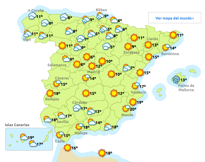
Das Wetter am Samstag-28.02.2015

Bild

GOLFO DE CÁDIZ-2.7

Bild
Evento Fecha Hora (GMT)* Latitud Longitud Prof. (km) Int. (***) Máx. Mag. Tipo (**) Mag. Localización 1319473 27/02/2015 13:05:44 36.2867 -8.4271 20   2.7 4 GOLFO DE CÁDIZ

Teneriffa-SAN JOSÉ.ITF-1.7-FASNIA.ITF-1.5

Bild
Evento Fecha Hora (GMT)* Latitud Longitud Prof. (km) Int. (***) Máx. Mag. Tipo (**) Mag. Localización 1319425 27/02/2015 08:38:13 28.4154 -16.6727     1.7 4 NW SAN JOSÉ.ITF Evento Fecha Hora (GMT)* Latitud Longitud Prof. (km) Int. (***) Máx. Mag. Tipo (**) Mag. Localización 1319414 27/02/2015 03:44:49 28.2379 -16.3221 15   1.5 4 E FASNIA.ITF

Hintergrund: Athen droht mit »Flüchtlingsschwemme

Der griechische Zivilschutzminister Giannis Panousis drohte Europa am vergangenen Montag mit einer gigantischen neuen Flüchtlingswelle. Es ist bekannt, dass derzeit etwa 1,5 Millionen illegale Einwanderer in Griechenland Zuflucht gesucht haben. Und Iannis Panousis will sie möglichst schnell in andere europäische Staaten durchreichen – oder aber mehr Geld aus Brüssel. Seine Drohung: Ansonsten werde Athen in einem ersten Schritt 300 000 Immigranten Reisepapiere ausstellen und damit Europa überfluten. Die Ankündigung erfolgte schon am Montag, verbreitete sich wie ein Lauffeuer bei den europäischen Regierungschefs und wurde  auch in vielen europäischen Medien zitiert . Nur die meisten deutschen Leitmedien schauten weg. Dabei erinnert das Verhalten der Griechen an klassische Schutzgelderpressung. Vor allem im deutschsprachigen Raum ist es bei unseren Leitmedien zu dieser Thematik gerade erstaunlich still . Man muss dabei wissen, dass Deutschland bei diesem Thema extrem

Trotz Verstimmung: Bundestag nickt Griechenlandhilfen ab

Der deutsche Bundestag hat am Freitag erwartungsgemäß mit großer Mehrheit den Griechenlandhilfen zugestimmt. Nur 32 Abgeordnete stimmten dagegen, 13 enthielten sich. Finanzminister Wolfgang Schäuble hat Verständnis für den wachsenden Unmut. Die Entscheidung über eine Verlängerung um weitere vier Monate falle keinem Abgeordneten des Deutschen Bundestages leicht, aber es gehe nicht um neue Milliarden für Griechenland. Es gehe auch nicht um neue Vereinbarungen. Es gehe darum, zusätzlich Zeit zur V…

Mexico volcano eruption causes further flight cancellations

Bild
A volcano east of Mexico city has forced the cancellation of several flights at a nearby airport for the second time in 10 days. The Popocatepetl volcano spewed ash into the sky following a series of tremors over the weekend. Its latest eruption also caused hot rocks to fly more than 700 metres into the air. … READ MORE : http://www.euronews.com/2015/02/26/me...

Massive very deep harmless earthquake below the Flores Sea, Indonesia – NO tsunami risk

Bild
Last update: February 27, 2015 at 2:35 pm Earthquake-report Important Message : NO tsunami risk due to the depth Update 14:00 UTC : Based on preliminary data, the hypocenter is located at 550 km below the surface. A light to max moderate shaking wille be felt in a wide area of a couple of thousand km BUT there NO reason at all to believe that damage will be inflicted. 113km (70mi) N of Nebe, Indonesia 133km (83mi) NNE of Maumere, Indonesia 180km (112mi) NNE of Ende, Indonesia 219km (136mi) S of Baubau, Indonesia 358km (222mi) WNW of Dili, East Timor

Tsunami Information-Message pacific.TIBPAC.2015.02.27.1357

Bild
Message pacific.TIBPAC.2015.02.27.1357 Tsunami Information Earthquake Information Message Time: 27 Feb 2015 13:57 UTC Message Num: 1 Message Text: click to read Message Type: Ptwc Tsunami Information Statement Warning: none Watch: none ETAs / Obs: none Preliminary (PTWC) Origin Time: 30 Nov -0001 00:00 UTC Magnitude: 6.8 Mwp (reviewed by PTWC) Latitude: 7.5° S Longitude: 122.5° E Depth: Location: More Info.:

Tsunami Information-Message hawaii.TIBHWX.2015.02.27.1358

Bild
  Message hawaii.TIBHWX.2015.02.27.1358 Tsunami Information Earthquake Information Message Time: 27 Feb 2015 03:58 am HST Message Num: 1 Message Text: click to read Message Type: Tsunami Information Statement Warning: none Watch: none ETAs / Obs: none Preliminary (PTWC) Origin Time: 27 Feb 2015 3:45 am HST Magnitude: 6.8 Mwp (reviewed by PTWC) Latitude: 7.4° S Longitude: 122.5° E Depth: Location: Flores Sea

FLORES SEA-6.8-Tsunami information-FLORES SEA-5.1

Bild
Magnitude Mw 6.8 Region FLORES SEA Date time 2015-02-27 13:45:05.3 UTC Location 7.40 S ; 122.50 E Depth 548 km Distances 362 km W of Dili, East Timor / pop: 150,000 / local time: 22:45:05.3 2015-02-27 328 km N of Kupang, Indonesia / pop: 282,396 / local time: 21:45:05.3 2015-02-27 139 km N of Maumere, Indonesia / pop: 47,598 / local time: 21:45:05.3 2015-02-27 Source parameters reviewed by a seismologist More information at: Magnitude mb 5.1 Region FLORES SEA Date time 2015-02-27 15:27:56.8 UTC Location 7.48 S ; 122.52 E Depth 568 km Distances 368 km W of Dili, East Timor / pop: 150,000 / local time: 00:27:57.6 2015-02-28 316 km NW of Kupang, Indonesia / pop: 282,396 / local time: 23:27:57.6 2015-02-27 118 km N of Maumere, Indonesia / pop: 47,598 / local time: 23:27:57.6 2015-02-27 Source parameters provided by:   National Earthquake Information Center, U.S. Geological Survey -- Golden, USA (NEIR)   USGS/NEIC Denver, USA   GeoForschungsZentru

EGYPT-4.5

Bild
Magnitude mb 4.5 Region EGYPT Date time 2015-02-27 12:53:08.4 UTC Location 31.78 N ; 30.91 E Depth 10 km Distances 110 km NE of Alexandria, Egypt / pop: 3,811,516 / local time: 14:53:08.4 2015-02-27 74 km N of Kafr ash Shaykh, Egypt / pop: 143,970 / local time: 14:53:08.4 2015-02-27 57 km NW of Al Ḩāmūl, Egypt / pop: 45,798 / local time: 14:53:08.4 2015-02-27 Source parameters reviewed by a seismologist

RYUKYU ISLANDS, JAPAN-5.1

Bild
Magnitude M 5.1 Region RYUKYU ISLANDS, JAPAN Date time 2015-02-27 07:58:04.0 UTC Location 28.29 N ; 128.31 E Depth 125 km Distances 623 km S of Fukuoka-shi, Japan / pop: 1,392,289 / local time: 16:58:04.0 2015-02-27 238 km N of Naha-shi, Japan / pop: 300,795 / local time: 16:58:04.0 2015-02-27 115 km W of Naze, Japan / pop: 41,365 / local time: 16:58:04.0 2015-02-27 Source parameters provided by:

MUNERA.ALBACETE-2.2-2.3-EL BONILLO.ALBACETE-1.6-1.9

Bild
Evento Fecha Hora (GMT)* Latitud Longitud Prof. (km) Int. (***) Máx. Mag. Tipo (**) Mag. Localización 1319405 27/02/2015 03:25:49 39.0540 -2.6347 11   2.2 4 W MUNERA.AB 2.2 W MUNERA.AB 2015/02/27 03:25:49 11 2.3 W MUNERA.AB 2015/02/27 02:32:58 11 1.6 NW EL BONILLO.AB 2015/02/27 02:09:41 11 1.9 NW EL BONILLO.AB 2015/02/26 23:54:31 11

OFFSHORE BAJA CALIFORNIA, MEXICO-3.4

Bild
Magnitude Ml 3.4 Region OFFSHORE BAJA CALIFORNIA, MEXICO Date time 2015-02-27 00:43:45.8 UTC Location 32.22 N ; 117.69 W Depth 21 km Distances 72 km SW of Tijuana, Mexico / pop: 1,376,457 / local time: 16:43:45.8 2015-02-26 63 km W of Rosarito, Mexico / pop: 66,020 / local time: 16:43:45.8 2015-02-26 Source parameters provided by:

NORTHERN ITALY-2.2-2.3-2.8

Bild
Magnitude ML 2.2 Region NORTHERN ITALY Date time 2015-02-26 22:35:27.8 UTC Location 44.19 N ; 10.90 E Depth 11 km Distances 196 km SE of Milan, Italy / pop: 1,306,661 / local time: 23:35:27.8 2015-02-26 49 km SW of Bologna, Italy / pop: 371,217 / local time: 23:35:27.8 2015-02-26 30 km N of Pistoia, Italy / pop: 84,274 / local time: 23:35:27.8 2015-02-26 13 km NW of Taviano, Italy / pop: 1,693 / local time: 23:35:27.8 2015-02-26 Source parameters provided by: Magnitude ML 2.3 Region NORTHERN ITALY Date time 2015-02-27 05:17:49.4 UTC Location 45.92 N ; 10.65 E Depth 7 km Distances 125 km NE of Milan, Italy / pop: 1,306,661 / local time: 06:17:49.4 2015-02-27 40 km SW of Trento, Italy / pop: 104,946 / local time: 06:17:49.4 2015-02-27 11 km NW of Molina di Ledro, Italy / pop: 1,498 / local time: 06:17:49.4 2015-02-27 Source parameters provided by: Magnitude ML 2.8 Region NORTHERN ITALY Date time 2015-02-27 05:53:13.2 UTC Location 44.19 N ; 10.90 E Dept

ROMANIA-4.2

Bild
Magnitude ML 4.2 Region ROMANIA Date time 2015-02-27 06:11:40.1 UTC Location 45.73 N ; 26.67 E Depth 130 km Distances 151 km N of Bucharest, Romania / pop: 1,877,155 / local time: 08:11:40.1 2015-02-27 40 km W of Focşani, Romania / pop: 105,112 / local time: 08:11:40.1 2015-02-27 4 km W of Nereju, Romania / pop: 4,202 / local time: 08:11:40.1 2015-02-27 Source parameters provided by:

SWITZERLAND-2.2

Bild
Magnitude ML 2.2 Region SWITZERLAND Date time 2015-02-27 07:25:16.4 UTC Location 47.22 N ; 7.24 E Depth 8 km Distances 34 km NW of Bern, Switzerland / pop: 121,631 / local time: 08:25:16.4 2015-02-27 30 km SW of Laufen, Switzerland / pop: 5,210 / local time: 08:25:16.4 2015-02-27 2 km SE of Reconvilier, Switzerland / pop: 2,291 / local time: 08:25:16.4 2015-02-27 Source parameters provided by:

GERMANY-2.0

Bild
Magnitude ML 2.0 Region GERMANY Date time 2015-02-27 02:30:33.6 UTC Location 50.42 N ; 7.33 E Depth 20 km Distances 124 km NE of Luxembourg, Luxembourg / pop: 76,684 / local time: 03:30:33.6 2015-02-27 76 km NW of Wiesbaden, Germany / pop: 272,432 / local time: 03:30:33.6 2015-02-27 63 km SE of Köln, Germany / pop: 963,395 / local time: 03:30:33.6 2015-02-27 5 km W of Andernach, Germany / pop: 29,599 / local time: 03:30:33.6 2015-02-27 Source parameters provided by:

GEFÜHLTES BEBEN-MUTXAMEL.ALICANTE-1.9

Bild
Evento Fecha Hora (GMT)* Latitud Longitud Prof. (km) Int. (***) Máx. Mag. Tipo (**) Mag. Localización 1319355 26/02/2015 20:58:33 38.4294 -0.4798 13 Sentido 1.9 4 NW MUTXAMEL.A

GALICIEN-RIÓS.OURENSE-2.0

Bild
Evento Fecha Hora (GMT)* Latitud Longitud Prof. (km) Int. (***) Máx. Mag. Tipo (**) Mag. Localización 1319349 26/02/2015 20:23:05 42.0419 -7.2810 11   2.0 4 N RIÓS.OU

Alerta ROT-ÜBERSCHWEMMUNGEN

Bild
Überschwemmungsgefahr Das Navarra Ebro hatte drei kurz hintereinander Überschwemmungen erlitten. Der Wasserverband erwarten eine Flut von "außergewöhnlich" Stärke in der Arga und Ebro Flüsse.  Warnungen im Einzelnen: Navarra, Zaragoza, Ascó und Tortosa (Tarragona). Fünfzehn Provinzen sind in Alarmbereitschaft für Wind, Schnee-Schmelze oder Lawinengefahr.   Das Ebro-Becken erwarten eine Flut von "außergewöhnlich" Stärke in der Arga und Ebro Flüsse nach starken Regenfällen, die Navarra in den letzten Tagen beeinflussen. Navarra hat das Niveau 1-Warnung für Überschwemmungen und  die Gemeinden in der Region erwarten mit Sorge den Verlauf der nächsten Stunden. Die Situation löste auch die Warnung in mehreren verschiedenen Orten von Aragon aus, der die Spitze des Hochwassers am Freitag  zeigte.  Katalonien durchströmt den Ebro und  Zaragoza oder die Bevölkerung von Asco rechnen mit starkem Hochwaser. Das Volumen des Flusses hat sich fast verd

Das Wetter am Freitag-27.02.2015

Bild

Zeit der Passionsraupen- Vorsicht sie sind wieder da!

Bild
    Die Prozessionsraupen  sind je nach Wärme ab Januar zu finden. In diesem Jahr schlüpfen sie besonders früh, wegen der voran gegangenen Kälte. Ihre Nester sitzen in den Kronen der Pinien und die Nester sehen aus wie aus  Zuckerwatte. Aber so unangenehm die Raupen für Mensch und Tier sein können, so unglaublich ist auch ihre Wandlungsfähigkeit. Die Prozessionsraupen schlüpfen aus den Eiern des Prozessionsspinners, eine graue Falterart, die von Mitte Juni bis Ende August fliegt und in dieser Zeit auch ihre Eier an den Pinien- und Kiefernnadeln ablegt. Im Januar dann schlüpfen in der Regel die Larven und beginnen mit dem Bau ihrer Nester. Ihren Namen verdanken die Prozessionsraupen der Angewohnheit, zur Nahrungssuche immer gemeinsam in einer Art Prozession aufzubrechen, eine Raupe kriecht voran und alle anderen aus dem Nest schließen sich lückenlos an, Kopf an Hinterteil. Dabei entsteht eine Raupenkolonne, die gut mehrere Meter lang

ATLÁNTICO-GALICIA-1.9

Bild
Evento Fecha Hora (GMT)* Latitud Longitud Prof. (km) Int. (***) Máx. Mag. Tipo (**) Mag. Localización 1319246 26/02/2015 09:20:56 42.4113 -9.0710     1.9 4 ATLÁNTICO-GALICIA

MONTENEGRO-2.8

Bild
Magnitude ML 2.8 Region MONTENEGRO Date time 2015-02-26 11:49:03.0 UTC Location 43.19 N ; 18.75 E Depth 4 km Distances 80 km SE of Sarajevo, Bosnia and Herzegovina / pop: 696,731 / local time: 12:49:03.0 2015-02-26 18 km E of Gacko, Bosnia and Herzegovina / pop: 3,417 / local time: 12:49:03.0 2015-02-26 Source parameters provided by: